Pomona geodata
Pomona (Queensland) is a section of populated place; located in Australia in Australia/Brisbane (GMT+10) time zone. With population of 2,820 people, there are 2367 cities with bigger population in this country. Compared to other cities in Australia, 88% of cities are located further ↓South; 87.8% of cities are located further ←West and 68.7% of cities have lower elevation than Pomona. Note1


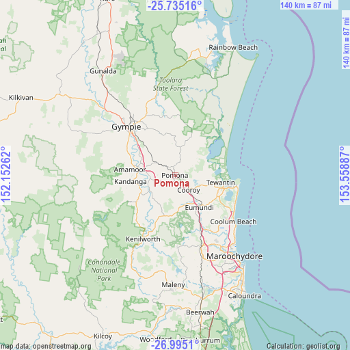
Pomona GPS coordinates[2]
26° 22' 0.66" South, 152° 51' 20.664" East
| Map corner | latitude | longitude |
|---|---|---|
| Upper-left | -25.73516°, | 152.15262° |
| Center: | -26.36685°, | 152.85574° |
| Lower-right: | -26.9951°, | 153.55887° |
| Map W x H: | 140.1×140.1 km | = 87.1×87.1mi |
| max Lat: | -10.58257° ⇑12% North |
| Pomona: | -26.36685° |
| min Lat: | ⇓88% South -43.31423° |
| min Long | Pomona | max Long |
| 113.53327° | 152.85574° | 153.61246° |
| W 87.8%⇐ | ⇒12.2% E |
Elevation
Elevation of Pomona is 95 m = 312 ft, and this is 27 m = 89 ft below average elevation for this country.
| Max E: |
1715 m = 5627 ft | 31.3% |
| Avg. | 122 m = 400 ft | |
| Pomona | 95 m = 312 ft | |
Min E: |
-2 m = -7 ft | 68.7% |
See also: Australia elevation on elevation.city.
Geographical zone
Pomona is located in South temperate zone (between Tropic of Capricorn and the Antarctic Circle). Distance of this Southern Tropic circle is 325.8 km =202.4 mi to North.| Distance of | km | miles | from Pomona |
|---|---|---|---|
| Equator | 2931.7 | 1821.7 | to North |
| Tropic Capricorn | 325.8 | 202.4 | to North |
| Antarctic Circle | 4469.5 | 2777.2 | to South |
| South Pole | 7075.3 | 4396.4 | to South |


Nearby cities:
15 places around Pomona: (largest is in red/bold)
• Amamoor
17.7 km =11 mi,  276°
276°
• Belli Park
16.1 km =10 mi,  192°
192°
• Black Mountain
4.1 km =2.5 mi,  150°
150°
• Cooran
4.7 km =2.9 mi,  315°
315°
• Cooroibah
13 km =8.1 mi,  88°
88°
• Cooroy
7.9 km =4.9 mi,  135°
135°
• Cootharaba
15.7 km =9.8 mi,  44°
44°
• Doonan
15.8 km =9.8 mi,  120°
120°
• Eerwah Vale
13.7 km =8.5 mi,  156°
156°
• Eumundi
15.5 km =9.6 mi, 142°
• Kin Kin
10.9 km =6.8 mi,  11°
11°
• Lake Macdonald
7.9 km =4.9 mi,  104°
104°
• Mothar Mountain
15.4 km =9.6 mi,  327°
327°
• Tewantin
18 km =11.2 mi, 98°
• Tinbeerwah
13.3 km =8.3 mi,  108°
108°
Sources, notices
• [Note1] Compared only with cities in Australia existing in our database
• [Src1] Map data: © OpenStreetMap contributors (CC-BY-SA)
• [Src2] Other city data from geonames.org with taken over terms of usage.
• [Src3] Geographical zone / Annual Mean Temperature by Robert A. Rohde @ Wikipedia
