Cootharaba geodata
Cootharaba (Queensland) is a section of populated place; located in Australia in Australia/Brisbane (GMT+10) time zone. With population of 843 people, there are 4070 cities with bigger population in this country. Compared to other cities in Australia, 88.2% of cities are located further ↓South; 90% of cities are located further ←West and 63.7% of cities have higher elevation than Cootharaba. Note1


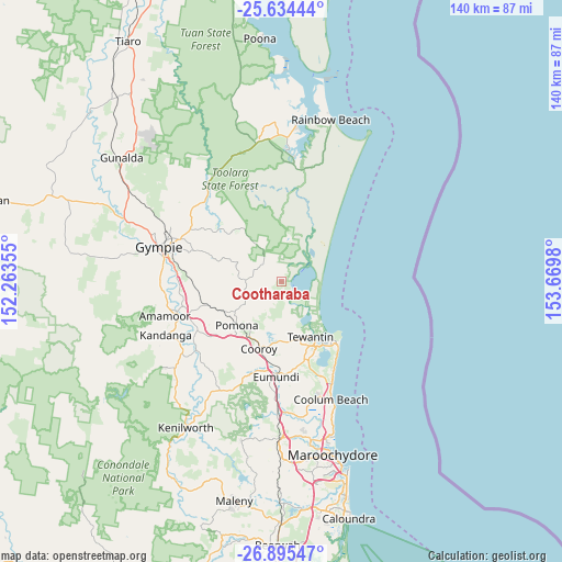
Cootharaba GPS coordinates[2]
26° 16' 0.012" South, 152° 58' 0.012" East
| Map corner | latitude | longitude |
|---|---|---|
| Upper-left | -25.63444°, | 152.26355° |
| Center: | -26.26667°, | 152.96667° |
| Lower-right: | -26.89547°, | 153.6698° |
| Map W x H: | 140.2×140.2 km | = 87.1×87.1mi |
| max Lat: | -10.58257° ⇑11.8% North |
| Cootharaba: | -26.26667° |
| min Lat: | ⇓88.2% South -43.31423° |
| min Long | Cootharaba | max Long |
| 113.53327° | 152.96667° | 153.61246° |
| W 90%⇐ | ⇒10% E |
Elevation
Elevation of Cootharaba is 28 m = 92 ft, and this is 94 m = 308 ft below average elevation for this country.
| Max E: |
1715 m = 5627 ft | 63.7% |
| Avg. | 122 m = 400 ft | |
| Cootharaba | 28 m = 92 ft | |
Min E: |
-2 m = -7 ft | 36.3% |
See also: Australia elevation on elevation.city.
Geographical zone
Cootharaba is located in South temperate zone (between Tropic of Capricorn and the Antarctic Circle). Distance of this Southern Tropic circle is 314.7 km =195.5 mi to North.| Distance of | km | miles | from Cootharaba |
|---|---|---|---|
| Equator | 2920.6 | 1814.8 | to North |
| Tropic Capricorn | 314.7 | 195.5 | to North |
| Antarctic Circle | 4480.6 | 2784.1 | to South |
| South Pole | 7086.5 | 4403.3 | to South |


Nearby cities:
15 places around Cootharaba: (largest is in red/bold)
• Black Mountain
17.3 km =10.7 mi,  211°
211°
• Cooran
16.4 km =10.2 mi,  241°
241°
• Cooroibah
10.9 km =6.8 mi,  169°
169°
• Cooroy
17.7 km =11 mi,  198°
198°
• Doonan
19.4 km =12.1 mi, 172°
• Kin Kin
8.9 km =5.5 mi,  267°
267°
• Lake Macdonald
13.6 km =8.5 mi,  194°
194°
• Mothar Mountain
19.3 km =12 mi,  275°
275°
• Noosa Heads
18.8 km =11.7 mi,  139°
139°
• Noosaville
17.9 km =11.1 mi,  146°
146°
• Pomona
15.7 km =9.8 mi,  224°
224°
• Sunrise Beach
21.5 km =13.4 mi, 140°
• Sunshine Beach
20.9 km =13 mi, 137°
• Tewantin
15.4 km =9.6 mi, 154°
• Tinbeerwah
15.4 km =9.6 mi, 174°
Sources, notices
• [Note1] Compared only with cities in Australia existing in our database
• [Src1] Map data: © OpenStreetMap contributors (CC-BY-SA)
• [Src2] Other city data from geonames.org with taken over terms of usage.
• [Src3] Geographical zone / Annual Mean Temperature by Robert A. Rohde @ Wikipedia
