Maraylya geodata
Maraylya (New South Wales) is a section of populated place; located in Australia in Australia/Sydney (GMT+11) time zone. With population of 1,211 people, there are 3565 cities with bigger population in this country. Compared to other cities in Australia, 52.7% of cities are located further ↓South; 66.1% of cities are located further ←West and 58.4% of cities have higher elevation than Maraylya. Note1


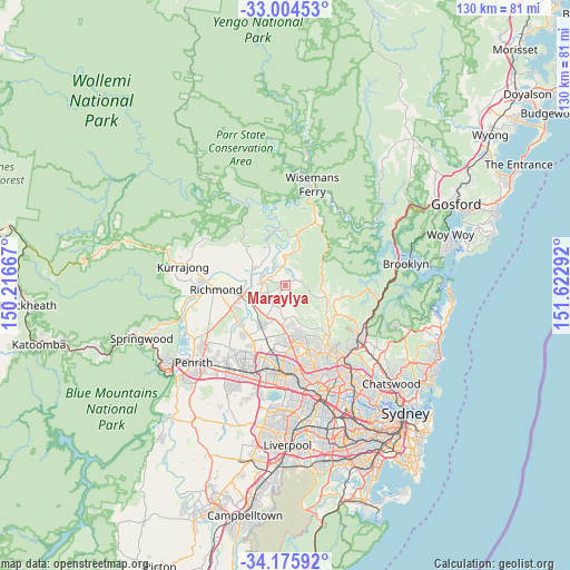
Maraylya GPS coordinates[2]
33° 35' 31.956" South, 150° 55' 11.244" East
| Map corner | latitude | longitude |
|---|---|---|
| Upper-left | -33.00453°, | 150.21667° |
| Center: | -33.59221°, | 150.91979° |
| Lower-right: | -34.17592°, | 151.62292° |
| Map W x H: | 130.2×130.2 km | = 80.9×80.9mi |
| max Lat: | -10.58257° ⇑47.3% North |
| Maraylya: | -33.59221° |
| min Lat: | ⇓52.7% South -43.31423° |
| min Long | Maraylya | max Long |
| 113.53327° | 150.91979° | 153.61246° |
| W 66.1%⇐ | ⇒33.9% E |
Elevation
Elevation of Maraylya is 34 m = 112 ft, and this is 88 m = 289 ft below average elevation for this country.
| Max E: |
1715 m = 5627 ft | 58.4% |
| Avg. | 122 m = 400 ft | |
| Maraylya | 34 m = 112 ft | |
Min E: |
-2 m = -7 ft | 41.6% |
See also: Australia elevation on elevation.city.
Geographical zone
Maraylya is located in South temperate zone (between Tropic of Capricorn and the Antarctic Circle). Distance of this Southern Tropic circle is 1129.2 km =701.7 mi to North.| Distance of | km | miles | from Maraylya |
|---|---|---|---|
| Equator | 3735.1 | 2320.9 | to North |
| Tropic Capricorn | 1129.2 | 701.7 | to North |
| Antarctic Circle | 3666.1 | 2278 | to South |
| South Pole | 6272 | 3897.2 | to South |


Nearby cities:
15 places around Maraylya: (largest is in red/bold)
• Annangrove
7.7 km =4.8 mi,  160°
160°
• Arcadia
10.9 km =6.8 mi,  104°
104°
• Cattai
5.2 km =3.2 mi,  354°
354°
• Ebenezer
8.6 km =5.3 mi,  338°
338°
• Glenorie
8.3 km =5.2 mi, 97°
• Kenthurst
10.6 km =6.6 mi,  131°
131°
• McGraths Hill
8.4 km =5.2 mi,  251°
251°
• Middle Dural
10.5 km =6.5 mi,  120°
120°
• Oakville
4.5 km =2.8 mi,  234°
234°
• Pitt Town
5.7 km =3.5 mi,  275°
275°
• Rouse Hill
10 km =6.2 mi,  182°
182°
• South Maroota
10.4 km =6.5 mi,  19°
19°
• Vineyard
8.9 km =5.5 mi,  224°
224°
• Wilberforce
8.3 km =5.2 mi,  293°
293°
• Windsor
10.1 km =6.3 mi,  256°
256°
Sources, notices
• [Note1] Compared only with cities in Australia existing in our database
• [Src1] Map data: © OpenStreetMap contributors (CC-BY-SA)
• [Src2] Other city data from geonames.org with taken over terms of usage.
• [Src3] Geographical zone / Annual Mean Temperature by Robert A. Rohde @ Wikipedia
