Teringie geodata
Teringie (South Australia) is a section of populated place; located in Australia in Australia/Adelaide (GMT+10.5) time zone. With population of 794 people, there are 4162 cities with bigger population in this country. Compared to other cities in Australia, 68.8% of cities are located further ↑North; 78.1% of cities are located further →East and 88.5% of cities have lower elevation than Teringie. Note1


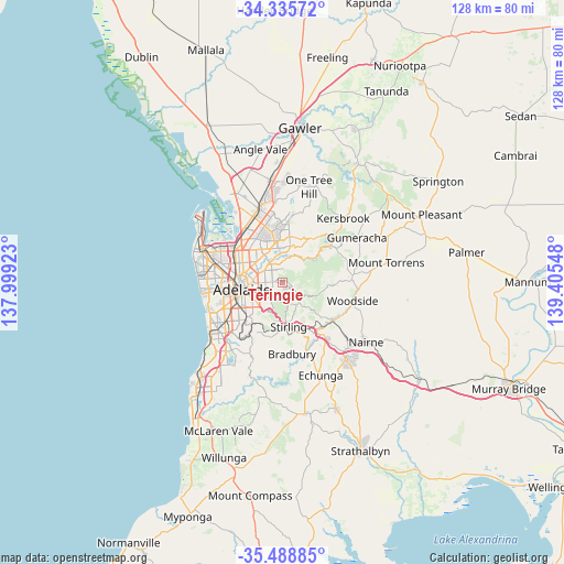
Teringie GPS coordinates[2]
34° 54' 51.516" South, 138° 42' 8.46" East
| Map corner | latitude | longitude |
|---|---|---|
| Upper-left | -34.33572°, | 137.99923° |
| Center: | -34.91431°, | 138.70235° |
| Lower-right: | -35.48885°, | 139.40548° |
| Map W x H: | 128.2×128.2 km | = 79.7×79.7mi |
| max Lat: | -10.58257° ⇑68.8% North |
| Teringie: | -34.91431° |
| min Lat: | ⇓31.2% South -43.31423° |
| min Long | Teringie | max Long |
| 113.53327° | 138.70235° | 153.61246° |
| W 21.9%⇐ | ⇒78.1% E |
Elevation
Elevation of Teringie is 328 m = 1076 ft, and this is 206 m = 676 ft above average elevation for this country.
| Max E: |
1715 m = 5627 ft | 11.5% |
| Teringie | 328 m 1076 ft | |
| Avg. | 122 m = 400 ft | |
Min E: |
-2 m = -7 ft | 88.5% |
See also: Australia elevation on elevation.city.
Geographical zone
Teringie is located in South temperate zone (between Tropic of Capricorn and the Antarctic Circle). Distance of this Southern Tropic circle is 1276.2 km =793 mi to North.| Distance of | km | miles | from Teringie |
|---|---|---|---|
| Equator | 3882.1 | 2412.2 | to North |
| Tropic Capricorn | 1276.2 | 793 | to North |
| Antarctic Circle | 3519.1 | 2186.7 | to South |
| South Pole | 6125 | 3805.9 | to South |


Nearby cities:
15 places around Teringie: (largest is in red/bold)
• Adelaide Hills
0.6 km =0.4 mi,  52°
52°
• Auldana
1.5 km =0.9 mi,  253°
253°
• Erindale
3.9 km =2.4 mi, 247°
• Kensington Gardens
3.9 km =2.4 mi, 251°
• Kensington Park
4.4 km =2.7 mi,  261°
261°
• Leabrook
4.3 km =2.7 mi, 246°
• Magill
2.6 km =1.6 mi,  283°
283°
• Newton
4 km =2.5 mi,  333°
333°
• Norton Summit
2.3 km =1.4 mi,  114°
114°
• Rosslyn Park
2.6 km =1.6 mi, 250°
• Rostrevor
2.5 km =1.6 mi,  337°
337°
• Stonyfell
3.2 km =2 mi,  226°
226°
• Tranmere
3.8 km =2.4 mi, 284°
• Wattle Park
2.8 km =1.7 mi,  244°
244°
• Woodforde
1.5 km =0.9 mi,  311°
311°
Sources, notices
• [Note1] Compared only with cities in Australia existing in our database
• [Src1] Map data: © OpenStreetMap contributors (CC-BY-SA)
• [Src2] Other city data from geonames.org with taken over terms of usage.
• [Src3] Geographical zone / Annual Mean Temperature by Robert A. Rohde @ Wikipedia
