Woodforde geodata
Woodforde (South Australia) is a section of populated place; located in Australia in Australia/Adelaide (GMT+10.5) time zone. With population of 605 people, there are 4554 cities with bigger population in this country. Compared to other cities in Australia, 68.4% of cities are located further ↑North; 78.3% of cities are located further →East and 81.4% of cities have lower elevation than Woodforde. Note1


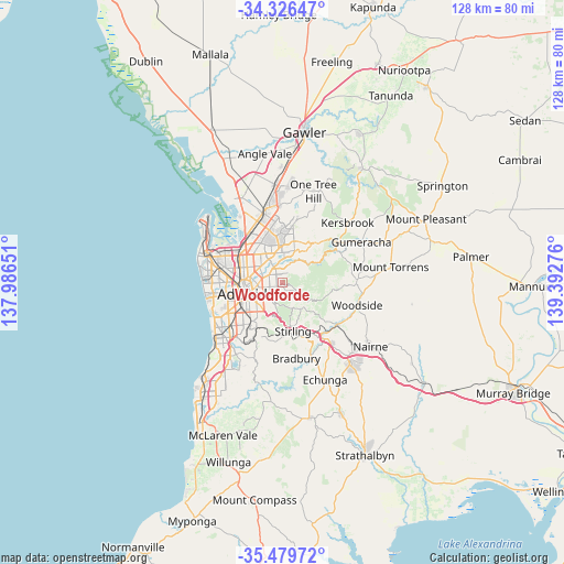
Woodforde GPS coordinates[2]
34° 54' 18.432" South, 138° 41' 22.668" East
| Map corner | latitude | longitude |
|---|---|---|
| Upper-left | -34.32647°, | 137.98651° |
| Center: | -34.90512°, | 138.68963° |
| Lower-right: | -35.47972°, | 139.39276° |
| Map W x H: | 128.2×128.2 km | = 79.7×79.7mi |
| max Lat: | -10.58257° ⇑68.4% North |
| Woodforde: | -34.90512° |
| min Lat: | ⇓31.6% South -43.31423° |
| min Long | Woodforde | max Long |
| 113.53327° | 138.68963° | 153.61246° |
| W 21.7%⇐ | ⇒78.3% E |
Elevation
Elevation of Woodforde is 196 m = 643 ft, and this is 74 m = 243 ft above average elevation for this country.
| Max E: |
1715 m = 5627 ft | 18.6% |
| Woodforde | 196 m 643 ft | |
| Avg. | 122 m = 400 ft | |
Min E: |
-2 m = -7 ft | 81.4% |
See also: Australia elevation on elevation.city.
Geographical zone
Woodforde is located in South temperate zone (between Tropic of Capricorn and the Antarctic Circle). Distance of this Southern Tropic circle is 1275.2 km =792.4 mi to North.| Distance of | km | miles | from Woodforde |
|---|---|---|---|
| Equator | 3881.1 | 2411.6 | to North |
| Tropic Capricorn | 1275.2 | 792.4 | to North |
| Antarctic Circle | 3520.1 | 2187.3 | to South |
| South Pole | 6126 | 3806.5 | to South |


Nearby cities:
15 places around Woodforde: (largest is in red/bold)
• Adelaide Hills
1.8 km =1.1 mi,  112°
112°
• Auldana
1.5 km =0.9 mi,  189°
189°
• Campbelltown
3.2 km =2 mi,  319°
319°
• Firle
3.3 km =2.1 mi,  271°
271°
• Hectorville
3.2 km =2 mi,  298°
298°
• Kensington Gardens
3.4 km =2.1 mi,  228°
228°
• Magill
1.4 km =0.9 mi,  251°
251°
• Newton
2.6 km =1.6 mi,  345°
345°
• Rosslyn Park
2.3 km =1.4 mi,  214°
214°
• Rostrevor
1.3 km =0.8 mi,  9°
9°
• St Morris
3.4 km =2.1 mi,  258°
258°
• Stonyfell
3.4 km =2.1 mi,  199°
199°
• Teringie
1.5 km =0.9 mi,  131°
131°
• Tranmere
2.5 km =1.6 mi, 269°
• Wattle Park
2.6 km =1.6 mi, 210°
Sources, notices
• [Note1] Compared only with cities in Australia existing in our database
• [Src1] Map data: © OpenStreetMap contributors (CC-BY-SA)
• [Src2] Other city data from geonames.org with taken over terms of usage.
• [Src3] Geographical zone / Annual Mean Temperature by Robert A. Rohde @ Wikipedia
