Pottsville geodata
Pottsville (New South Wales) is a populated place; located in Australia in Australia/Sydney (GMT+11) time zone. With population of 6,692 people, there are 1034 cities with bigger population in this country. Compared to other cities in Australia, 74.7% of cities are located further ↓South; 99.8% of cities are located further ←West and 90.1% of cities have higher elevation than Pottsville. Note1


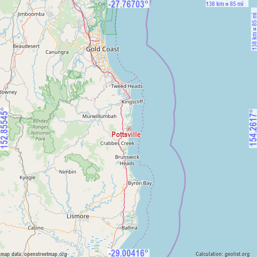
Pottsville GPS coordinates[2]
28° 23' 14.64" South, 153° 33' 30.852" East
| Map corner | latitude | longitude |
|---|---|---|
| Upper-left | -27.76703°, | 152.85545° |
| Center: | -28.3874°, | 153.55857° |
| Lower-right: | -29.00416°, | 154.2617° |
| Map W x H: | 137.6×137.6 km | = 85.5×85.5mi |
| max Lat: | -10.58257° ⇑25.3% North |
| Pottsville: | -28.3874° |
| min Lat: | ⇓74.7% South -43.31423° |
| min Long | Pottsville | max Long |
| 113.53327° | 153.55857° | 153.61246° |
| W 99.8%⇐ | ⇒0.2% E |
Elevation
Elevation of Pottsville is 9 m = 30 ft, and this is 113 m = 371 ft below average elevation for this country.
| Max E: |
1715 m = 5627 ft | 90.1% |
| Avg. | 122 m = 400 ft | |
| Pottsville | 9 m = 30 ft | |
Min E: |
-2 m = -7 ft | 9.9% |
See also: Australia elevation on elevation.city.
Geographical zone
Pottsville is located in South temperate zone (between Tropic of Capricorn and the Antarctic Circle). Distance of this Southern Tropic circle is 550.5 km =342.1 mi to North.| Distance of | km | miles | from Pottsville |
|---|---|---|---|
| Equator | 3156.4 | 1961.3 | to North |
| Tropic Capricorn | 550.5 | 342.1 | to North |
| Antarctic Circle | 4244.8 | 2637.6 | to South |
| South Pole | 6850.7 | 4256.8 | to South |


Nearby cities:
15 places around Pottsville: (largest is in red/bold)
• Bogangar
6.5 km =4 mi,  8°
8°
• Brunswick Heads
17 km =10.6 mi,  184°
184°
• Burringbar
9.9 km =6.2 mi,  237°
237°
• Casuarina
9.7 km =6 mi, 6°
• Chinderah
14.9 km =9.3 mi,  351°
351°
• Cudgen
13.5 km =8.4 mi,  356°
356°
• Hastings Point
3 km =1.9 mi,  31°
31°
• Kingscliff
14.3 km =8.9 mi, 7°
• Murwillumbah
17.5 km =10.9 mi,  292°
292°
• Nunderi
12.1 km =7.5 mi,  306°
306°
• Ocean Shores
13.7 km =8.5 mi,  188°
188°
• Pottsville Beach
0.7 km =0.4 mi,  100°
100°
• South Golden Beach
12.3 km =7.6 mi, 185°
• South Murwillumbah
16.4 km =10.2 mi, 289°
• Stokers Siding
14.3 km =8.9 mi,  260°
260°
Sources, notices
• [Note1] Compared only with cities in Australia existing in our database
• [Src1] Map data: © OpenStreetMap contributors (CC-BY-SA)
• [Src2] Other city data from geonames.org with taken over terms of usage.
• [Src3] Geographical zone / Annual Mean Temperature by Robert A. Rohde @ Wikipedia
