Cattai geodata
Cattai (New South Wales) is a section of populated place; located in Australia in Australia/Sydney (GMT+11) time zone. With population of 822 people, there are 4106 cities with bigger population in this country. Compared to other cities in Australia, 53% of cities are located further ↓South; 65.9% of cities are located further ←West and 64.8% of cities have higher elevation than Cattai. Note1


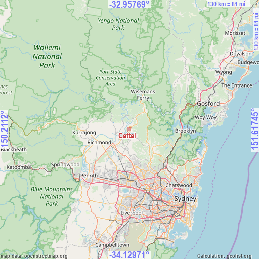
Cattai GPS coordinates[2]
33° 32' 44.484" South, 150° 54' 51.552" East
| Map corner | latitude | longitude |
|---|---|---|
| Upper-left | -32.95769°, | 150.2112° |
| Center: | -33.54569°, | 150.91432° |
| Lower-right: | -34.12971°, | 151.61745° |
| Map W x H: | 130.3×130.3 km | = 81×81mi |
| max Lat: | -10.58257° ⇑47% North |
| Cattai: | -33.54569° |
| min Lat: | ⇓53% South -43.31423° |
| min Long | Cattai | max Long |
| 113.53327° | 150.91432° | 153.61246° |
| W 65.9%⇐ | ⇒34.1% E |
Elevation
Elevation of Cattai is 27 m = 89 ft, and this is 95 m = 312 ft below average elevation for this country.
| Max E: |
1715 m = 5627 ft | 64.8% |
| Avg. | 122 m = 400 ft | |
| Cattai | 27 m = 89 ft | |
Min E: |
-2 m = -7 ft | 35.2% |
See also: Australia elevation on elevation.city.
Geographical zone
Cattai is located in South temperate zone (between Tropic of Capricorn and the Antarctic Circle). Distance of this Southern Tropic circle is 1124 km =698.4 mi to North.| Distance of | km | miles | from Cattai |
|---|---|---|---|
| Equator | 3729.9 | 2317.7 | to North |
| Tropic Capricorn | 1124 | 698.4 | to North |
| Antarctic Circle | 3671.2 | 2281.2 | to South |
| South Pole | 6277.1 | 3900.4 | to South |


Nearby cities:
15 places around Cattai: (largest is in red/bold)
• Annangrove
12.8 km =8 mi,  166°
166°
• East Kurrajong
12 km =7.5 mi,  291°
291°
• Ebenezer
3.9 km =2.4 mi,  317°
317°
• Freemans Reach
11.1 km =6.9 mi,  262°
262°
• Glenorie
10.8 km =6.7 mi,  125°
125°
• Lower Portland
11 km =6.8 mi,  344°
344°
• Maraylya
5.2 km =3.2 mi, 174°
• Maroota
11.3 km =7 mi,  34°
34°
• McGraths Hill
10.8 km =6.7 mi,  223°
223°
• Oakville
8.4 km =5.2 mi,  202°
202°
• Pitt Town
6.9 km =4.3 mi,  228°
228°
• South Maroota
6.1 km =3.8 mi,  40°
40°
• Vineyard
12.9 km =8 mi,  206°
206°
• Wilberforce
7.3 km =4.5 mi, 255°
• Windsor
11.9 km =7.4 mi, 231°
Sources, notices
• [Note1] Compared only with cities in Australia existing in our database
• [Src1] Map data: © OpenStreetMap contributors (CC-BY-SA)
• [Src2] Other city data from geonames.org with taken over terms of usage.
• [Src3] Geographical zone / Annual Mean Temperature by Robert A. Rohde @ Wikipedia
