Carwoola geodata
Carwoola (New South Wales) is a section of populated place; located in Australia in Australia/Sydney (GMT+11) time zone. With population of 1,406 people, there are 3362 cities with bigger population in this country. Compared to other cities in Australia, 76.4% of cities are located further ↑North; 55.9% of cities are located further ←West and 99% of cities have lower elevation than Carwoola. Note1


Carwoola GPS coordinates[2]
35° 22' 42.096" South, 149° 19' 17.4" East
| Map corner | latitude | longitude |
|---|---|---|
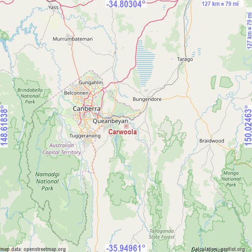
| Upper-left | -34.80304°, | 148.61838° |
| Center: | -35.37836°, | 149.3215° |
| Lower-right: | -35.94961°, | 150.02463° |
| Map W x H: | 127.5×127.5 km | = 79.2×79.2mi |
| max Lat: | -10.58257° ⇑76.4% North |
| Carwoola: | -35.37836° |
| min Lat: | ⇓23.6% South -43.31423° |
| min Long | Carwoola | max Long |
| 113.53327° | 149.3215° | 153.61246° |
| W 55.9%⇐ | ⇒44.1% E |
Elevation
Elevation of Carwoola is 809 m = 2654 ft, and this is 687 m = 2254 ft above average elevation for this country.
| Max E: |
1715 m = 5627 ft | 1% |
| Carwoola | 809 m 2654 ft | |
| Avg. | 122 m = 400 ft | |
Min E: |
-2 m = -7 ft | 99% |
See also: Australia elevation on elevation.city.
Geographical zone
Carwoola is located in South temperate zone (between Tropic of Capricorn and the Antarctic Circle). Distance of this Southern Tropic circle is 1327.8 km =825.1 mi to North.| Distance of | km | miles | from Carwoola |
|---|---|---|---|
| Equator | 3933.7 | 2444.3 | to North |
| Tropic Capricorn | 1327.8 | 825.1 | to North |
| Antarctic Circle | 3467.5 | 2154.6 | to South |
| South Pole | 6073.4 | 3773.8 | to South |


Nearby cities:
15 places around Carwoola: (largest is in red/bold)
• Bungendore
17.5 km =10.9 mi,  37°
37°
• Crestwood
10 km =6.2 mi,  289°
289°
• Gilmore
17.5 km =10.9 mi,  254°
254°
• Googong
11.9 km =7.4 mi,  235°
235°
• Greenleigh
6.4 km =4 mi,  281°
281°
• Griffith
17.7 km =11 mi, 289°
• Jerrabomberra
10.8 km =6.7 mi,  266°
266°
• Karabar
8 km =5 mi, 271°
• Kingston
17.3 km =10.7 mi, 293°
• Narrabundah
16.3 km =10.1 mi, 286°
• Queanbeyan
8.5 km =5.3 mi, 287°
• Queanbeyan East
7.7 km =4.8 mi,  297°
297°
• Queanbeyan West
11 km =6.8 mi, 283°
• Symonston
15 km =9.3 mi, 281°
• Wamboin
14.2 km =8.8 mi,  4°
4°
Sources, notices
• [Note1] Compared only with cities in Australia existing in our database
• [Src1] Map data: © OpenStreetMap contributors (CC-BY-SA)
• [Src2] Other city data from geonames.org with taken over terms of usage.
• [Src3] Geographical zone / Annual Mean Temperature by Robert A. Rohde @ Wikipedia
