North Isis geodata
North Isis (Queensland) is a section of populated place; located in Australia in Australia/Brisbane (GMT+10) time zone. With population of 540 people, there are 4749 cities with bigger population in this country. Compared to other cities in Australia, 89.6% of cities are located further ↓South; 83.4% of cities are located further ←West and 62.1% of cities have lower elevation than North Isis. Note1


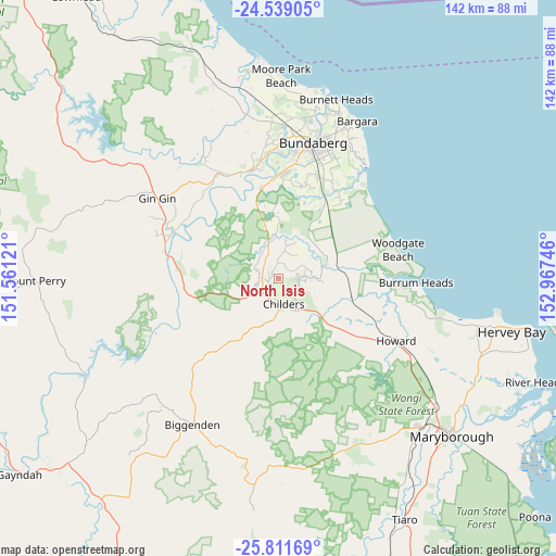
North Isis GPS coordinates[2]
25° 10' 37.308" South, 152° 15' 51.588" East
| Map corner | latitude | longitude |
|---|---|---|
| Upper-left | -24.53905°, | 151.56121° |
| Center: | -25.17703°, | 152.26433° |
| Lower-right: | -25.81169°, | 152.96746° |
| Map W x H: | 141.5×141.5 km | = 87.9×87.9mi |
| max Lat: | -10.58257° ⇑10.4% North |
| North Isis: | -25.17703° |
| min Lat: | ⇓89.6% South -43.31423° |
| min Long | North Isis | max Long |
| 113.53327° | 152.26433° | 153.61246° |
| W 83.4%⇐ | ⇒16.6% E |
Elevation
Elevation of North Isis is 70 m = 230 ft, and this is 52 m = 171 ft below average elevation for this country.
| Max E: |
1715 m = 5627 ft | 37.9% |
| Avg. | 122 m = 400 ft | |
| North Isis | 70 m = 230 ft | |
Min E: |
-2 m = -7 ft | 62.1% |
See also: Australia elevation on elevation.city.
Geographical zone
North Isis is located in South temperate zone (between Tropic of Capricorn and the Antarctic Circle). Distance of this Southern Tropic circle is 193.5 km =120.2 mi to North.| Distance of | km | miles | from North Isis |
|---|---|---|---|
| Equator | 2799.4 | 1739.5 | to North |
| Tropic Capricorn | 193.5 | 120.2 | to North |
| Antarctic Circle | 4601.8 | 2859.4 | to South |
| South Pole | 7207.6 | 4478.6 | to South |


Nearby cities:
15 places around North Isis: (largest is in red/bold)
• Apple Tree Creek
5.4 km =3.4 mi,  215°
215°
• Avenell Heights
33.6 km =20.9 mi,  18°
18°
• Avoca
33.5 km =20.8 mi,  7°
7°
• Branyan
29.3 km =18.2 mi,  1°
1°
• Childers
6.8 km =4.2 mi,  167°
167°
• Kensington
29.4 km =18.3 mi, 10°
• Norville
32.5 km =20.2 mi, 13°
• Pacific Haven
30.6 km =19 mi,  108°
108°
• Redridge
9.8 km =6.1 mi,  85°
85°
• Sharon
33.5 km =20.8 mi, 0°
• South Bingera
23.7 km =14.7 mi,  349°
349°
• South Kolan
28.9 km =18 mi,  340°
340°
• Svensson Heights
33.1 km =20.6 mi, 11°
• Thabeban
32 km =19.9 mi, 15°
• Woodgate
31 km =19.3 mi,  75°
75°
Sources, notices
• [Note1] Compared only with cities in Australia existing in our database
• [Src1] Map data: © OpenStreetMap contributors (CC-BY-SA)
• [Src2] Other city data from geonames.org with taken over terms of usage.
• [Src3] Geographical zone / Annual Mean Temperature by Robert A. Rohde @ Wikipedia
