Childers geodata
Childers (Queensland) is a populated place; located in Australia in Australia/Brisbane (GMT+10) time zone. With population of 1,613 people, there are 3173 cities with bigger population in this country. Compared to other cities in Australia, 89.5% of cities are located further ↓South; 83.5% of cities are located further ←West and 72.3% of cities have lower elevation than Childers. Note1


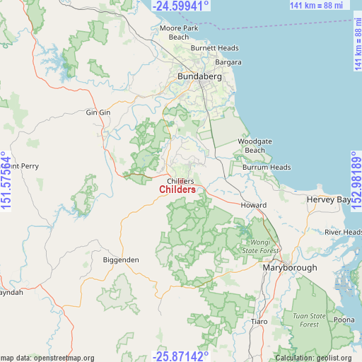
Childers GPS coordinates[2]
25° 14' 13.488" South, 152° 16' 43.536" East
| Map corner | latitude | longitude |
|---|---|---|
| Upper-left | -24.59941°, | 151.57564° |
| Center: | -25.23708°, | 152.27876° |
| Lower-right: | -25.87142°, | 152.98189° |
| Map W x H: | 141.4×141.4 km | = 87.9×87.9mi |
| max Lat: | -10.58257° ⇑10.5% North |
| Childers: | -25.23708° |
| min Lat: | ⇓89.5% South -43.31423° |
| min Long | Childers | max Long |
| 113.53327° | 152.27876° | 153.61246° |
| W 83.5%⇐ | ⇒16.5% E |
Elevation
Elevation of Childers is 114 m = 374 ft, and this is 8 m = 26 ft below average elevation for this country.
| Max E: |
1715 m = 5627 ft | 27.7% |
| Avg. | 122 m = 400 ft | |
| Childers | 114 m = 374 ft | |
Min E: |
-2 m = -7 ft | 72.3% |
See also: Australia elevation on elevation.city.
Geographical zone
Childers is located in South temperate zone (between Tropic of Capricorn and the Antarctic Circle). Distance of this Southern Tropic circle is 200.2 km =124.4 mi to North.| Distance of | km | miles | from Childers |
|---|---|---|---|
| Equator | 2806.1 | 1743.6 | to North |
| Tropic Capricorn | 200.2 | 124.4 | to North |
| Antarctic Circle | 4595.1 | 2855.3 | to South |
| South Pole | 7201 | 4474.5 | to South |


Nearby cities:
15 places around Childers: (largest is in red/bold)
• Apple Tree Creek
5.1 km =3.2 mi,  296°
296°
• Biggenden
38.3 km =23.8 mi,  217°
217°
• Branyan
36 km =22.4 mi,  358°
358°
• Burrum Heads
34.1 km =21.2 mi,  80°
80°
• Howard
29.7 km =18.5 mi,  107°
107°
• Kensington
35.8 km =22.2 mi,  6°
6°
• North Isis
6.8 km =4.2 mi,  347°
347°
• Norville
38.8 km =24.1 mi, 9°
• Pacific Haven
27.7 km =17.2 mi,  96°
96°
• Redridge
11.2 km =7 mi,  48°
48°
• South Bingera
30.5 km =19 mi, 349°
• South Kolan
35.7 km =22.2 mi,  341°
341°
• Thabeban
38.2 km =23.7 mi, 10°
• Torbanlea
33.9 km =21.1 mi, 110°
• Woodgate
31.9 km =19.8 mi,  63°
63°
Sources, notices
• [Note1] Compared only with cities in Australia existing in our database
• [Src1] Map data: © OpenStreetMap contributors (CC-BY-SA)
• [Src2] Other city data from geonames.org with taken over terms of usage.
• [Src3] Geographical zone / Annual Mean Temperature by Robert A. Rohde @ Wikipedia
