Brentwood geodata
Brentwood (Western Australia) is a section of populated place; located in Australia in Australia/Perth (GMT+8) time zone. With population of 2,024 people, there are 2888 cities with bigger population in this country. Compared to other cities in Australia, 64.3% of cities are located further ↓South; 94.7% of cities are located further →East and 81.9% of cities have higher elevation than Brentwood. Note1


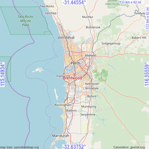
Brentwood GPS coordinates[2]
32° 2' 36.492" South, 115° 51' 8.856" East
| Map corner | latitude | longitude |
|---|---|---|
| Upper-left | -31.44554°, | 115.14934° |
| Center: | -32.04347°, | 115.85246° |
| Lower-right: | -32.63752°, | 116.55559° |
| Map W x H: | 132.5×132.5 km | = 82.3×82.3mi |
| max Lat: | -10.58257° ⇑35.7% North |
| Brentwood: | -32.04347° |
| min Lat: | ⇓64.3% South -43.31423° |
| min Long | Brentwood | max Long |
| 113.53327° | 115.85246° | 153.61246° |
| W 5.3%⇐ | ⇒94.7% E |
Elevation
Elevation of Brentwood is 14 m = 46 ft, and this is 108 m = 354 ft below average elevation for this country.
| Max E: |
1715 m = 5627 ft | 81.9% |
| Avg. | 122 m = 400 ft | |
| Brentwood | 14 m = 46 ft | |
Min E: |
-2 m = -7 ft | 18.1% |
See also: Australia elevation on elevation.city.
Geographical zone
Brentwood is located in South temperate zone (between Tropic of Capricorn and the Antarctic Circle). Distance of this Southern Tropic circle is 957 km =594.7 mi to North.| Distance of | km | miles | from Brentwood |
|---|---|---|---|
| Equator | 3562.9 | 2213.9 | to North |
| Tropic Capricorn | 957 | 594.7 | to North |
| Antarctic Circle | 3838.3 | 2385 | to South |
| South Pole | 6444.2 | 4004.2 | to South |


Nearby cities:
15 places around Brentwood: (largest is in red/bold)
• Applecross
3.5 km =2.2 mi,  328°
328°
• Ardross
2.4 km =1.5 mi,  318°
318°
• Bateman
1.4 km =0.9 mi,  199°
199°
• Booragoon
1.8 km =1.1 mi,  284°
284°
• Bull Creek
1.7 km =1.1 mi,  146°
146°
• Leeming
3.7 km =2.3 mi,  159°
159°
• Manning
3.4 km =2.1 mi,  24°
24°
• Mount Pleasant
0.5 km =0.3 mi, 330°
• Murdoch
3.3 km =2.1 mi,  205°
205°
• Myaree
3.3 km =2.1 mi, 276°
• Rossmoyne
1.5 km =0.9 mi,  73°
73°
• Salter Point
2.5 km =1.6 mi,  29°
29°
• Shelley
3.6 km =2.2 mi,  64°
64°
• Willetton
3.5 km =2.2 mi,  106°
106°
• Winthrop
2.4 km =1.5 mi,  245°
245°
Sources, notices
• [Note1] Compared only with cities in Australia existing in our database
• [Src1] Map data: © OpenStreetMap contributors (CC-BY-SA)
• [Src2] Other city data from geonames.org with taken over terms of usage.
• [Src3] Geographical zone / Annual Mean Temperature by Robert A. Rohde @ Wikipedia
