Booragoon geodata
Booragoon (Western Australia) is a section of populated place; located in Australia in Australia/Perth (GMT+8) time zone. With population of 5,404 people, there are 1375 cities with bigger population in this country. Compared to other cities in Australia, 64.5% of cities are located further ↓South; 95.2% of cities are located further →East and 69.8% of cities have higher elevation than Booragoon. Note1


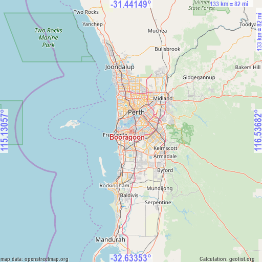
Booragoon GPS coordinates[2]
32° 2' 22.02" South, 115° 50' 1.284" East
| Map corner | latitude | longitude |
|---|---|---|
| Upper-left | -31.44149°, | 115.13057° |
| Center: | -32.03945°, | 115.83369° |
| Lower-right: | -32.63353°, | 116.53682° |
| Map W x H: | 132.5×132.5 km | = 82.3×82.3mi |
| max Lat: | -10.58257° ⇑35.5% North |
| Booragoon: | -32.03945° |
| min Lat: | ⇓64.5% South -43.31423° |
| min Long | Booragoon | max Long |
| 113.53327° | 115.83369° | 153.61246° |
| W 4.8%⇐ | ⇒95.2% E |
Elevation
Elevation of Booragoon is 23 m = 75 ft, and this is 99 m = 325 ft below average elevation for this country.
| Max E: |
1715 m = 5627 ft | 69.8% |
| Avg. | 122 m = 400 ft | |
| Booragoon | 23 m = 75 ft | |
Min E: |
-2 m = -7 ft | 30.2% |
See also: Australia elevation on elevation.city.
Geographical zone
Booragoon is located in South temperate zone (between Tropic of Capricorn and the Antarctic Circle). Distance of this Southern Tropic circle is 956.5 km =594.3 mi to North.| Distance of | km | miles | from Booragoon |
|---|---|---|---|
| Equator | 3562.5 | 2213.6 | to North |
| Tropic Capricorn | 956.5 | 594.3 | to North |
| Antarctic Circle | 3838.7 | 2385.3 | to South |
| South Pole | 6444.6 | 4004.5 | to South |


Nearby cities:
15 places around Booragoon: (largest is in red/bold)
• Alfred Cove
2.1 km =1.3 mi,  289°
289°
• Applecross
2.5 km =1.6 mi,  359°
359°
• Ardross
1.4 km =0.9 mi,  6°
6°
• Attadale
3.4 km =2.1 mi,  298°
298°
• Bateman
2.2 km =1.4 mi,  144°
144°
• Brentwood
1.8 km =1.1 mi,  104°
104°
• Bull Creek
3.3 km =2.1 mi,  124°
124°
• Kardinya
3.4 km =2.1 mi,  211°
211°
• Melville
3.1 km =1.9 mi,  268°
268°
• Mount Pleasant
1.5 km =0.9 mi,  91°
91°
• Murdoch
3.4 km =2.1 mi,  173°
173°
• Myaree
1.5 km =0.9 mi, 267°
• Rossmoyne
3.2 km =2 mi, 90°
• Willagee
3 km =1.9 mi,  242°
242°
• Winthrop
1.5 km =0.9 mi,  194°
194°
Sources, notices
• [Note1] Compared only with cities in Australia existing in our database
• [Src1] Map data: © OpenStreetMap contributors (CC-BY-SA)
• [Src2] Other city data from geonames.org with taken over terms of usage.
• [Src3] Geographical zone / Annual Mean Temperature by Robert A. Rohde @ Wikipedia
