Ardross geodata
Ardross (Western Australia) is a section of populated place; located in Australia in Australia/Perth (GMT+8) time zone. With population of 4,165 people, there are 1734 cities with bigger population in this country. Compared to other cities in Australia, 64.7% of cities are located further ↓South; 95.2% of cities are located further →East and 61.1% of cities have higher elevation than Ardross. Note1


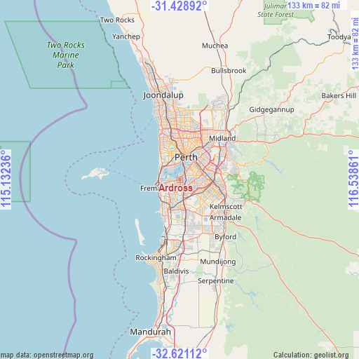
Ardross GPS coordinates[2]
32° 1' 37.056" South, 115° 50' 7.728" East
| Map corner | latitude | longitude |
|---|---|---|
| Upper-left | -31.42892°, | 115.13236° |
| Center: | -32.02696°, | 115.83548° |
| Lower-right: | -32.62112°, | 116.53861° |
| Map W x H: | 132.6×132.6 km | = 82.4×82.4mi |
| max Lat: | -10.58257° ⇑35.3% North |
| Ardross: | -32.02696° |
| min Lat: | ⇓64.7% South -43.31423° |
| min Long | Ardross | max Long |
| 113.53327° | 115.83548° | 153.61246° |
| W 4.8%⇐ | ⇒95.2% E |
Elevation
Elevation of Ardross is 31 m = 102 ft, and this is 91 m = 299 ft below average elevation for this country.
| Max E: |
1715 m = 5627 ft | 61.1% |
| Avg. | 122 m = 400 ft | |
| Ardross | 31 m = 102 ft | |
Min E: |
-2 m = -7 ft | 38.9% |
See also: Australia elevation on elevation.city.
Geographical zone
Ardross is located in South temperate zone (between Tropic of Capricorn and the Antarctic Circle). Distance of this Southern Tropic circle is 955.1 km =593.5 mi to North.| Distance of | km | miles | from Ardross |
|---|---|---|---|
| Equator | 3561.1 | 2212.8 | to North |
| Tropic Capricorn | 955.1 | 593.5 | to North |
| Antarctic Circle | 3840.1 | 2386.1 | to South |
| South Pole | 6446 | 4005.4 | to South |


Nearby cities:
15 places around Ardross: (largest is in red/bold)
• Alfred Cove
2.3 km =1.4 mi,  252°
252°
• Applecross
1.2 km =0.7 mi,  349°
349°
• Attadale
3.2 km =2 mi,  274°
274°
• Bateman
3.4 km =2.1 mi,  160°
160°
• Booragoon
1.4 km =0.9 mi,  186°
186°
• Brentwood
2.4 km =1.5 mi,  138°
138°
• Bull Creek
4.1 km =2.5 mi, 142°
• Manning
3.2 km =2 mi,  67°
67°
• Melville
3.6 km =2.2 mi, 245°
• Mount Pleasant
2 km =1.2 mi, 136°
• Myaree
2.2 km =1.4 mi,  229°
229°
• Rossmoyne
3.4 km =2.1 mi,  114°
114°
• Salter Point
2.9 km =1.8 mi,  83°
83°
• Willagee
4 km =2.5 mi, 225°
• Winthrop
2.9 km =1.8 mi, 190°
Sources, notices
• [Note1] Compared only with cities in Australia existing in our database
• [Src1] Map data: © OpenStreetMap contributors (CC-BY-SA)
• [Src2] Other city data from geonames.org with taken over terms of usage.
• [Src3] Geographical zone / Annual Mean Temperature by Robert A. Rohde @ Wikipedia
