Netherby geodata
Netherby (South Australia) is a section of populated place; located in Australia in Australia/Adelaide (GMT+10.5) time zone. With population of 1,389 people, there are 3384 cities with bigger population in this country. Compared to other cities in Australia, 70.5% of cities are located further ↑North; 80.5% of cities are located further →East and 67.3% of cities have lower elevation than Netherby. Note1


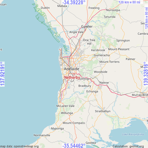
Netherby GPS coordinates[2]
34° 58' 13.728" South, 138° 37' 30.108" East
| Map corner | latitude | longitude |
|---|---|---|
| Upper-left | -34.39228°, | 137.92191° |
| Center: | -34.97048°, | 138.62503° |
| Lower-right: | -35.54462°, | 139.32816° |
| Map W x H: | 128.1×128.1 km | = 79.6×79.6mi |
| max Lat: | -10.58257° ⇑70.5% North |
| Netherby: | -34.97048° |
| min Lat: | ⇓29.5% South -43.31423° |
| min Long | Netherby | max Long |
| 113.53327° | 138.62503° | 153.61246° |
| W 19.5%⇐ | ⇒80.5% E |
Elevation
Elevation of Netherby is 90 m = 295 ft, and this is 32 m = 105 ft below average elevation for this country.
| Max E: |
1715 m = 5627 ft | 32.7% |
| Avg. | 122 m = 400 ft | |
| Netherby | 90 m = 295 ft | |
Min E: |
-2 m = -7 ft | 67.3% |
See also: Australia elevation on elevation.city.
Geographical zone
Netherby is located in South temperate zone (between Tropic of Capricorn and the Antarctic Circle). Distance of this Southern Tropic circle is 1282.4 km =796.8 mi to North.| Distance of | km | miles | from Netherby |
|---|---|---|---|
| Equator | 3888.4 | 2416.1 | to North |
| Tropic Capricorn | 1282.4 | 796.8 | to North |
| Antarctic Circle | 3512.8 | 2182.8 | to South |
| South Pole | 6118.7 | 3802 | to South |


Nearby cities:
15 places around Netherby: (largest is in red/bold)
• Frewville
2.6 km =1.6 mi,  11°
11°
• Fullarton
2.2 km =1.4 mi, 9°
• Glen Osmond
2.5 km =1.6 mi,  60°
60°
• Glenunga
2.6 km =1.6 mi,  28°
28°
• Hawthorn
1.7 km =1.1 mi,  256°
256°
• Highgate
1 km =0.6 mi,  343°
343°
• Lower Mitcham
2 km =1.2 mi,  247°
247°
• Malvern
1.7 km =1.1 mi,  317°
317°
• Mitcham
1 km =0.6 mi,  197°
197°
• Myrtle Bank
1.4 km =0.9 mi,  35°
35°
• Springfield
1.1 km =0.7 mi,  141°
141°
• Torrens Park
1.5 km =0.9 mi, 245°
• Unley Park
1.7 km =1.1 mi,  295°
295°
• Urrbrae
1.6 km =1 mi,  73°
73°
• Westbourne Park
2.7 km =1.7 mi,  267°
267°
Sources, notices
• [Note1] Compared only with cities in Australia existing in our database
• [Src1] Map data: © OpenStreetMap contributors (CC-BY-SA)
• [Src2] Other city data from geonames.org with taken over terms of usage.
• [Src3] Geographical zone / Annual Mean Temperature by Robert A. Rohde @ Wikipedia
