Springfield geodata
Springfield (South Australia) is a section of populated place; located in Australia in Australia/Adelaide (GMT+10.5) time zone. With population of 518 people, there are 4823 cities with bigger population in this country. Compared to other cities in Australia, 70.8% of cities are located further ↑North; 80.2% of cities are located further →East and 78.3% of cities have lower elevation than Springfield. Note1


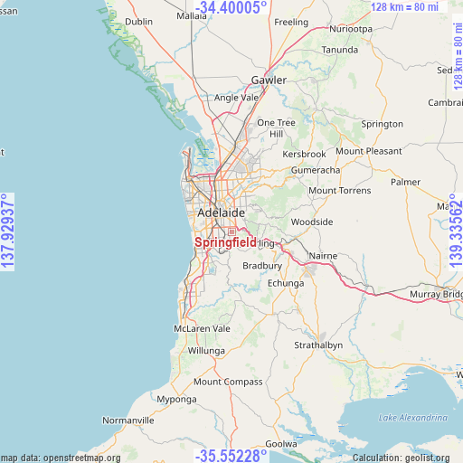
Springfield GPS coordinates[2]
34° 58' 41.484" South, 138° 37' 56.964" East
| Map corner | latitude | longitude |
|---|---|---|
| Upper-left | -34.40005°, | 137.92937° |
| Center: | -34.97819°, | 138.63249° |
| Lower-right: | -35.55228°, | 139.33562° |
| Map W x H: | 128.1×128.1 km | = 79.6×79.6mi |
| max Lat: | -10.58257° ⇑70.8% North |
| Springfield: | -34.97819° |
| min Lat: | ⇓29.2% South -43.31423° |
| min Long | Springfield | max Long |
| 113.53327° | 138.63249° | 153.61246° |
| W 19.8%⇐ | ⇒80.2% E |
Elevation
Elevation of Springfield is 159 m = 522 ft, and this is 37 m = 121 ft above average elevation for this country.
| Max E: |
1715 m = 5627 ft | 21.7% |
| Springfield | 159 m 522 ft | |
| Avg. | 122 m = 400 ft | |
Min E: |
-2 m = -7 ft | 78.3% |
See also: Australia elevation on elevation.city.
Geographical zone
Springfield is located in South temperate zone (between Tropic of Capricorn and the Antarctic Circle). Distance of this Southern Tropic circle is 1283.3 km =797.4 mi to North.| Distance of | km | miles | from Springfield |
|---|---|---|---|
| Equator | 3889.2 | 2416.6 | to North |
| Tropic Capricorn | 1283.3 | 797.4 | to North |
| Antarctic Circle | 3512 | 2182.3 | to South |
| South Pole | 6117.9 | 3801.5 | to South |


Nearby cities:
15 places around Springfield: (largest is in red/bold)
• Belair
2.4 km =1.5 mi,  206°
206°
• Clapham
3.1 km =1.9 mi,  245°
245°
• Fullarton
3 km =1.9 mi,  353°
353°
• Glen Osmond
2.5 km =1.6 mi,  35°
35°
• Glenunga
3.2 km =2 mi,  9°
9°
• Hawthorn
2.3 km =1.4 mi,  281°
281°
• Highgate
2.1 km =1.3 mi,  331°
331°
• Lower Mitcham
2.5 km =1.6 mi,  272°
272°
• Malvern
2.8 km =1.7 mi,  319°
319°
• Mitcham
1 km =0.6 mi, 265°
• Myrtle Bank
2 km =1.2 mi,  3°
3°
• Netherby
1.1 km =0.7 mi, 321°
• Torrens Park
2 km =1.2 mi, 276°
• Unley Park
2.8 km =1.7 mi,  305°
305°
• Urrbrae
1.6 km =1 mi,  33°
33°
Sources, notices
• [Note1] Compared only with cities in Australia existing in our database
• [Src1] Map data: © OpenStreetMap contributors (CC-BY-SA)
• [Src2] Other city data from geonames.org with taken over terms of usage.
• [Src3] Geographical zone / Annual Mean Temperature by Robert A. Rohde @ Wikipedia
