Kureelpa geodata
Kureelpa (Queensland) is a section of populated place; located in Australia in Australia/Brisbane (GMT+10) time zone. With population of 873 people, there are 4013 cities with bigger population in this country. Compared to other cities in Australia, 87.2% of cities are located further ↓South; 88.4% of cities are located further ←West and 83.7% of cities have lower elevation than Kureelpa. Note1


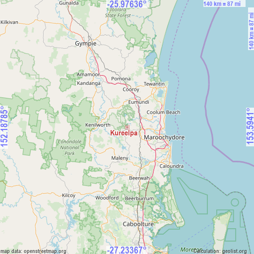
Kureelpa GPS coordinates[2]
26° 36' 24.264" South, 152° 53' 27.492" East
| Map corner | latitude | longitude |
|---|---|---|
| Upper-left | -25.97636°, | 152.18785° |
| Center: | -26.60674°, | 152.89097° |
| Lower-right: | -27.23367°, | 153.5941° |
| Map W x H: | 139.8×139.8 km | = 86.9×86.9mi |
| max Lat: | -10.58257° ⇑12.8% North |
| Kureelpa: | -26.60674° |
| min Lat: | ⇓87.2% South -43.31423° |
| min Long | Kureelpa | max Long |
| 113.53327° | 152.89097° | 153.61246° |
| W 88.4%⇐ | ⇒11.6% E |
Elevation
Elevation of Kureelpa is 226 m = 741 ft, and this is 104 m = 341 ft above average elevation for this country.
| Max E: |
1715 m = 5627 ft | 16.3% |
| Kureelpa | 226 m 741 ft | |
| Avg. | 122 m = 400 ft | |
Min E: |
-2 m = -7 ft | 83.7% |
See also: Australia elevation on elevation.city.
Geographical zone
Kureelpa is located in South temperate zone (between Tropic of Capricorn and the Antarctic Circle). Distance of this Southern Tropic circle is 352.5 km =219 mi to North.| Distance of | km | miles | from Kureelpa |
|---|---|---|---|
| Equator | 2958.4 | 1838.3 | to North |
| Tropic Capricorn | 352.5 | 219 | to North |
| Antarctic Circle | 4442.8 | 2760.6 | to South |
| South Pole | 7048.7 | 4379.9 | to South |


Nearby cities:
15 places around Kureelpa: (largest is in red/bold)
• Burnside
5.7 km =3.5 mi,  120°
120°
• Coes Creek
7.3 km =4.5 mi,  127°
127°
• Dulong
3.4 km =2.1 mi,  153°
153°
• Flaxton
6.2 km =3.9 mi,  205°
205°
• Hunchy
8.4 km =5.2 mi,  166°
166°
• Mapleton
3 km =1.9 mi,  229°
229°
• Montville
8.5 km =5.3 mi,  185°
185°
• Nambour
7.1 km =4.4 mi,  107°
107°
• Ninderry
11.1 km =6.9 mi,  48°
48°
• North Arm
11.1 km =6.9 mi,  35°
35°
• Palmwoods
11.2 km =7 mi,  141°
141°
• Rosemount
11.1 km =6.9 mi,  103°
103°
• West Woombye
7.5 km =4.7 mi, 152°
• Woombye
9.8 km =6.1 mi, 127°
• Yandina
8.2 km =5.1 mi, 52°
Sources, notices
• [Note1] Compared only with cities in Australia existing in our database
• [Src1] Map data: © OpenStreetMap contributors (CC-BY-SA)
• [Src2] Other city data from geonames.org with taken over terms of usage.
• [Src3] Geographical zone / Annual Mean Temperature by Robert A. Rohde @ Wikipedia
