Marrakai geodata
Marrakai (Northern Territory) is a populated place; located in Australia in Australia/Darwin (GMT+9.5) time zone. With population of 568 people, there are 4654 cities with bigger population in this country. Compared to other cities in Australia, 98.4% of cities are located further ↓South; 87.2% of cities are located further →East and 64.8% of cities have higher elevation than Marrakai. Note1


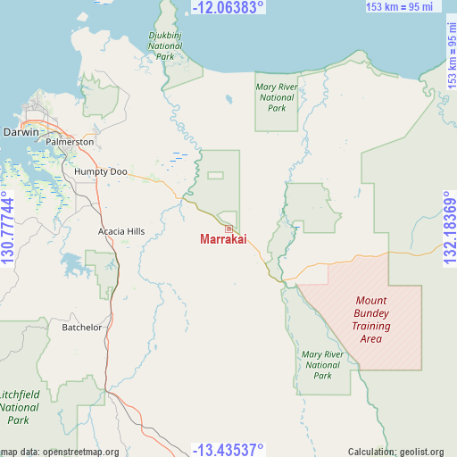
Marrakai GPS coordinates[2]
12° 45' 1.908" South, 131° 28' 50.016" East
| Map corner | latitude | longitude |
|---|---|---|
| Upper-left | -12.06383°, | 130.77744° |
| Center: | -12.75053°, | 131.48056° |
| Lower-right: | -13.43537°, | 132.18369° |
| Map W x H: | 152.5×152.5 km | = 94.8×94.8mi |
| max Lat: | -10.58257° ⇑1.6% North |
| Marrakai: | -12.75053° |
| min Lat: | ⇓98.4% South -43.31423° |
| min Long | Marrakai | max Long |
| 113.53327° | 131.48056° | 153.61246° |
| W 12.8%⇐ | ⇒87.2% E |
Elevation
Elevation of Marrakai is 27 m = 89 ft, and this is 95 m = 312 ft below average elevation for this country.
| Max E: |
1715 m = 5627 ft | 64.8% |
| Avg. | 122 m = 400 ft | |
| Marrakai | 27 m = 89 ft | |
Min E: |
-2 m = -7 ft | 35.2% |
See also: Australia elevation on elevation.city.
Geographical zone
Marrakai is located in South Torrid zone (between Equator and Tropic of Capricorn). Distance of this Southern Tropic circle is 1188.2 km =738.3 mi to South.| Distance of | km | miles | from Marrakai |
|---|---|---|---|
| Equator | 1417.7 | 880.9 | to North |
| Tropic Capricorn | 1188.2 | 738.3 | to South |
| Antarctic Circle | 5983.4 | 3717.9 | to South |
| South Pole | 8589.3 | 5337.1 | to South |


Nearby cities:
15 places around Marrakai: (largest is in red/bold)
• Acacia Hills
38.8 km =24.1 mi,  262°
262°
• Batchelor
59.1 km =36.7 mi,  235°
235°
• Bees Creek
49.5 km =30.8 mi,  292°
292°
• Bellamack
59.8 km =37.2 mi,  295°
295°
• Berry Springs
50.8 km =31.6 mi,  276°
276°
• Coolalinga
53.9 km =33.5 mi, 297°
• Darwin River
55.9 km =34.7 mi, 262°
• Girraween
48.7 km =30.3 mi, 300°
• Herbert
42.1 km =26.2 mi, 304°
• Howard Springs
55.1 km =34.2 mi, 300°
• Humpty Doo
41.6 km =25.8 mi, 296°
• Johnston
58.7 km =36.5 mi, 299°
• McMinns Lagoon
49.3 km =30.6 mi, 297°
• Virginia
55.4 km =34.4 mi, 297°
• Zuccoli
58.1 km =36.1 mi, 297°
Sources, notices
• [Note1] Compared only with cities in Australia existing in our database
• [Src1] Map data: © OpenStreetMap contributors (CC-BY-SA)
• [Src2] Other city data from geonames.org with taken over terms of usage.
• [Src3] Geographical zone / Annual Mean Temperature by Robert A. Rohde @ Wikipedia
