Batchelor geodata
Batchelor (Northern Territory) is a populated place; located in Australia in Australia/Darwin (GMT+9.5) time zone. With population of 661 people, there are 4404 cities with bigger population in this country. Compared to other cities in Australia, 98.3% of cities are located further ↓South; 87.4% of cities are located further →East and 72.8% of cities have lower elevation than Batchelor. Note1


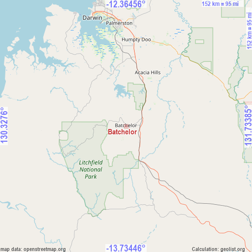
Batchelor GPS coordinates[2]
13° 3' 1.656" South, 131° 1' 50.592" East
| Map corner | latitude | longitude |
|---|---|---|
| Upper-left | -12.36456°, | 130.3276° |
| Center: | -13.05046°, | 131.03072° |
| Lower-right: | -13.73446°, | 131.73385° |
| Map W x H: | 152.3×152.3 km | = 94.6×94.6mi |
| max Lat: | -10.58257° ⇑1.7% North |
| Batchelor: | -13.05046° |
| min Lat: | ⇓98.3% South -43.31423° |
| min Long | Batchelor | max Long |
| 113.53327° | 131.03072° | 153.61246° |
| W 12.6%⇐ | ⇒87.4% E |
Elevation
Elevation of Batchelor is 116 m = 381 ft, and this is 6 m = 20 ft below average elevation for this country.
| Max E: |
1715 m = 5627 ft | 27.2% |
| Avg. | 122 m = 400 ft | |
| Batchelor | 116 m = 381 ft | |
Min E: |
-2 m = -7 ft | 72.8% |
See also: Australia elevation on elevation.city.
Geographical zone
Batchelor is located in South Torrid zone (between Equator and Tropic of Capricorn). Distance of this Southern Tropic circle is 1154.8 km =717.6 mi to South.| Distance of | km | miles | from Batchelor |
|---|---|---|---|
| Equator | 1451.1 | 901.7 | to North |
| Tropic Capricorn | 1154.8 | 717.6 | to South |
| Antarctic Circle | 5950.1 | 3697.2 | to South |
| South Pole | 8556 | 5316.5 | to South |


Nearby cities:
15 places around Batchelor: (largest is in red/bold)
• Acacia Hills
30.3 km =18.8 mi,  19°
19°
• Bees Creek
52.5 km =32.6 mi,  3°
3°
• Bellamack
59.5 km =37 mi,  355°
355°
• Berry Springs
39 km =24.2 mi, 357°
• Coolalinga
58.6 km =36.4 mi, 1°
• Darwin River
26.5 km =16.5 mi,  345°
345°
• Girraween
58.8 km =36.5 mi,  6°
6°
• Herbert
59.1 km =36.7 mi, 13°
• Humpty Doo
53.1 km =33 mi, 12°
• Marrakai
59.1 km =36.7 mi,  55°
55°
• McMinns Lagoon
56.1 km =34.9 mi, 5°
• Rosebery
60.2 km =37.4 mi, 355°
• Virginia
59.1 km =36.7 mi, 359°
• Wickham
56.4 km =35 mi, 347°
• Zuccoli
60.5 km =37.6 mi, 357°
Sources, notices
• [Note1] Compared only with cities in Australia existing in our database
• [Src1] Map data: © OpenStreetMap contributors (CC-BY-SA)
• [Src2] Other city data from geonames.org with taken over terms of usage.
• [Src3] Geographical zone / Annual Mean Temperature by Robert A. Rohde @ Wikipedia
