Mannum geodata
Mannum (South Australia) is a populated place; located in Australia in Australia/Adelaide (GMT+10.5) time zone. With population of 2,679 people, there are 2448 cities with bigger population in this country. Compared to other cities in Australia, 68.8% of cities are located further ↑North; 76.5% of cities are located further →East and 59.2% of cities have higher elevation than Mannum. Note1


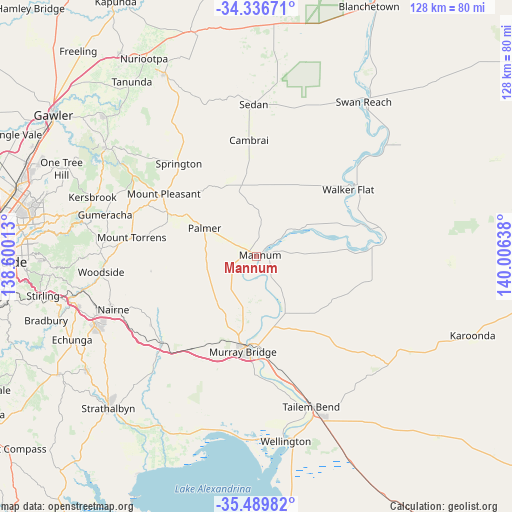
Mannum GPS coordinates[2]
34° 54' 55.044" South, 139° 18' 11.7" East
| Map corner | latitude | longitude |
|---|---|---|
| Upper-left | -34.33671°, | 138.60013° |
| Center: | -34.91529°, | 139.30325° |
| Lower-right: | -35.48982°, | 140.00638° |
| Map W x H: | 128.2×128.2 km | = 79.7×79.7mi |
| max Lat: | -10.58257° ⇑68.8% North |
| Mannum: | -34.91529° |
| min Lat: | ⇓31.2% South -43.31423° |
| min Long | Mannum | max Long |
| 113.53327° | 139.30325° | 153.61246° |
| W 23.5%⇐ | ⇒76.5% E |
Elevation
Elevation of Mannum is 33 m = 108 ft, and this is 89 m = 292 ft below average elevation for this country.
| Max E: |
1715 m = 5627 ft | 59.2% |
| Avg. | 122 m = 400 ft | |
| Mannum | 33 m = 108 ft | |
Min E: |
-2 m = -7 ft | 40.8% |
See also: Australia elevation on elevation.city.
Geographical zone
Mannum is located in South temperate zone (between Tropic of Capricorn and the Antarctic Circle). Distance of this Southern Tropic circle is 1276.3 km =793.1 mi to North.| Distance of | km | miles | from Mannum |
|---|---|---|---|
| Equator | 3882.2 | 2412.3 | to North |
| Tropic Capricorn | 1276.3 | 793.1 | to North |
| Antarctic Circle | 3519 | 2186.6 | to South |
| South Pole | 6124.8 | 3805.8 | to South |


Nearby cities:
15 places around Mannum: (largest is in red/bold)
• Birdwood
32.7 km =20.3 mi,  289°
289°
• Callington
32.9 km =20.4 mi,  226°
226°
• Charleston
36.8 km =22.9 mi,  269°
269°
• Gumeracha
39.5 km =24.5 mi,  284°
284°
• Kanmantoo
31.6 km =19.6 mi,  236°
236°
• Little Hampton
42.4 km =26.3 mi,  250°
250°
• Lobethal
39.1 km =24.3 mi, 271°
• Mount Pleasant
28 km =17.4 mi,  303°
303°
• Mount Torrens
31.7 km =19.7 mi, 278°
• Murray Bridge
22.9 km =14.2 mi,  186°
186°
• Nairne
38.1 km =23.7 mi, 249°
• Riverglades
20.5 km =12.7 mi,  180°
180°
• Springton
30.3 km =18.8 mi,  319°
319°
• Tailem Bend
39.9 km =24.8 mi,  159°
159°
• Woodside
38.9 km =24.2 mi,  263°
263°
Sources, notices
• [Note1] Compared only with cities in Australia existing in our database
• [Src1] Map data: © OpenStreetMap contributors (CC-BY-SA)
• [Src2] Other city data from geonames.org with taken over terms of usage.
• [Src3] Geographical zone / Annual Mean Temperature by Robert A. Rohde @ Wikipedia
