Mount Pleasant geodata
Mount Pleasant (South Australia) is a populated place; located in Australia in Australia/Adelaide (GMT+10.5) time zone. With population of 992 people, there are 3837 cities with bigger population in this country. Compared to other cities in Australia, 65.5% of cities are located further ↑North; 76.6% of cities are located further →East and 91.9% of cities have lower elevation than Mount Pleasant. Note1


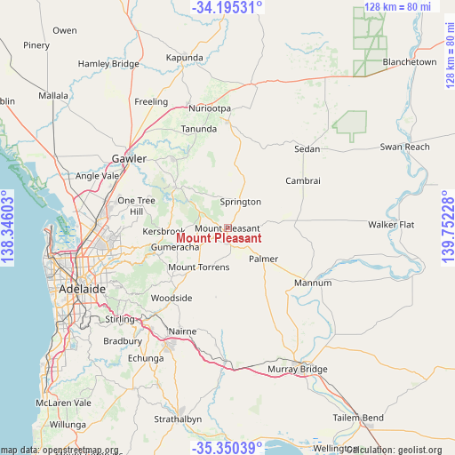
Mount Pleasant GPS coordinates[2]
34° 46' 29.532" South, 139° 2' 56.94" East
| Map corner | latitude | longitude |
|---|---|---|
| Upper-left | -34.19531°, | 138.34603° |
| Center: | -34.77487°, | 139.04915° |
| Lower-right: | -35.35039°, | 139.75228° |
| Map W x H: | 128.4×128.4 km | = 79.8×79.8mi |
| max Lat: | -10.58257° ⇑65.5% North |
| Mount Pleasant: | -34.77487° |
| min Lat: | ⇓34.5% South -43.31423° |
| min Long | Mount Pleasant | max Long |
| 113.53327° | 139.04915° | 153.61246° |
| W 23.4%⇐ | ⇒76.6% E |
Elevation
Elevation of Mount Pleasant is 439 m = 1440 ft, and this is 317 m = 1040 ft above average elevation for this country.
| Max E: |
1715 m = 5627 ft | 8.1% |
| Mount Pleasant | 439 m 1440 ft | |
| Avg. | 122 m = 400 ft | |
Min E: |
-2 m = -7 ft | 91.9% |
See also: Australia elevation on elevation.city.
Geographical zone
Mount Pleasant is located in South temperate zone (between Tropic of Capricorn and the Antarctic Circle). Distance of this Southern Tropic circle is 1260.7 km =783.4 mi to North.| Distance of | km | miles | from Mount Pleasant |
|---|---|---|---|
| Equator | 3866.6 | 2402.6 | to North |
| Tropic Capricorn | 1260.7 | 783.4 | to North |
| Antarctic Circle | 3534.6 | 2196.3 | to South |
| South Pole | 6140.5 | 3815.5 | to South |


Nearby cities:
15 places around Mount Pleasant: (largest is in red/bold)
• Banksia Park
28.9 km =18 mi,  262°
262°
• Birdwood
9.1 km =5.7 mi,  237°
237°
• Charleston
20.8 km =12.9 mi,  220°
220°
• Cockatoo Valley
25.6 km =15.9 mi,  310°
310°
• Golden Grove
28.9 km =18 mi,  268°
268°
• Gumeracha
16 km =9.9 mi,  250°
250°
• Kersbrook
18.1 km =11.2 mi, 267°
• Lobethal
21.5 km =13.4 mi,  227°
227°
• Lyndoch
24.1 km =15 mi,  323°
323°
• Mannum
28 km =17.4 mi,  123°
123°
• Mount Torrens
13.9 km =8.6 mi, 216°
• One Tree Hill
27.1 km =16.8 mi,  287°
287°
• Springton
8.3 km =5.2 mi,  26°
26°
• Williamstown
18.4 km =11.4 mi, 308°
• Woodside
25.3 km =15.7 mi, 217°
Sources, notices
• [Note1] Compared only with cities in Australia existing in our database
• [Src1] Map data: © OpenStreetMap contributors (CC-BY-SA)
• [Src2] Other city data from geonames.org with taken over terms of usage.
• [Src3] Geographical zone / Annual Mean Temperature by Robert A. Rohde @ Wikipedia
