Ağdaş geodata
Ağdaş is a seat of a first-order administrative division; located in Azerbaijan in Asia/Baku (GMT+4) time zone. With population of 23,528 people, there are 33 cities with bigger population in this country. Compared to other cities in Azerbaijan, 72.4% of cities are located further ↓South; 51.4% of cities are located further →East and 59.5% of cities have higher elevation than Ağdaş. Note1


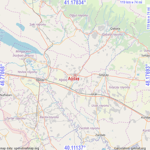
Ağdaş GPS coordinates[2]
40° 38' 49.164" North, 47° 28' 25.68" East
| Map corner | latitude | longitude |
|---|---|---|
| Upper-left | 41.17834°, | 46.77068° |
| Center: | 40.64699°, | 47.4738° |
| Lower-right: | 40.11137°, | 48.17693° |
| Map W x H: | 118.6×118.6 km | = 73.7×73.7mi |
| max Lat: | 41.75259° ⇑27.6% North |
| Ağdaş: | 40.64699° |
| min Lat: | ⇓72.4% South 38.45598° |
| min Long | Ağdaş | max Long |
| 44.84846° | 47.4738° | 50.84003° |
| W 48.6%⇐ | ⇒51.4% E |
Elevation
Elevation of Ağdaş is 50 m = 164 ft, and this is 333 m = 1093 ft below average elevation for this country.
| Max E: |
2211 m = 7254 ft | 59.5% |
| Avg. | 383 m = 1257 ft | |
| Ağdaş | 50 m = 164 ft | |
Min E: |
-26 m = -85 ft | 40.5% |
See also: Azerbaijan elevation on elevation.city.
Geographical zone
Ağdaş is located in North temperate zone (between Tropic of Cancer and the Arctic Circle). Distance of this Northern Tropic circle is 1913.6 km =1189.1 mi to South.| Distance of | km | miles | from Ağdaş |
|---|---|---|---|
| North Pole | 5487.5 | 3409.8 | to North |
| Arctic Circle | 2881.7 | 1790.6 | to North |
| Tropic Cancer | 1913.6 | 1189.1 | to South |
| Equator | 4519.5 | 2808.3 | to South |


Nearby cities:
15 places around Ağdaş: (largest is in red/bold)
• Aran
42.1 km =26.2 mi,  266°
266°
• Barda
42.1 km =26.2 mi,  224°
224°
• Begimli
52.9 km =32.9 mi,  146°
146°
• Geoktschai
22.6 km =14 mi,  88°
88°
• Mingelchaur
37.3 km =23.2 mi,  290°
290°
• Naftalan
57.3 km =35.6 mi,  254°
254°
• Oğuz
47.2 km =29.3 mi,  359°
359°
• Qaramanlı
44.6 km =27.7 mi, 245°
• Qutqashen
48.9 km =30.4 mi,  40°
40°
• Qızılhacılı
52.6 km =32.7 mi,  261°
261°
• Samuxlu
30 km =18.6 mi,  238°
238°
• Terter
57 km =35.4 mi,  233°
233°
• Ujar
20.8 km =12.9 mi,  133°
133°
• Yevlakh
27.5 km =17.1 mi, 263°
• Zardob
51.7 km =32.1 mi,  157°
157°
Sources, notices
• [Note1] Compared only with cities in Azerbaijan existing in our database
• [Src1] Map data: © OpenStreetMap contributors (CC-BY-SA)
• [Src2] Other city data from geonames.org with taken over terms of usage.
• [Src3] Geographical zone / Annual Mean Temperature by Robert A. Rohde @ Wikipedia
