Saatlı geodata
Saatlı is a seat of a first-order administrative division; located in Azerbaijan in Asia/Baku (GMT+4) time zone. With population of 87,000 people, there are 6 cities with bigger population in this country. Compared to other cities in Azerbaijan, 70.8% of cities are located further ↑North; 56.8% of cities are located further ←West and 85.4% of cities have higher elevation than Saatlı. Note1


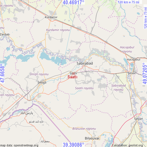
Saatlı GPS coordinates[2]
39° 55' 55.704" North, 48° 22' 8.112" East
| Map corner | latitude | longitude |
|---|---|---|
| Upper-left | 40.46917°, | 47.6658° |
| Center: | 39.93214°, | 48.36892° |
| Lower-right: | 39.39086°, | 49.07205° |
| Map W x H: | 119.9×119.9 km | = 74.5×74.5mi |
| max Lat: | 41.75259° ⇑70.8% North |
| Saatlı: | 39.93214° |
| min Lat: | ⇓29.2% South 38.45598° |
| min Long | Saatlı | max Long |
| 44.84846° | 48.36892° | 50.84003° |
| W 56.8%⇐ | ⇒43.2% E |
Elevation
Elevation of Saatlı is -7 m = -23 ft, and this is 390 m = 1280 ft below average elevation for this country.
| Max E: |
2211 m = 7254 ft | 85.4% |
| Avg. | 383 m = 1257 ft | |
| Saatlı | -7 m = -23 ft | |
Min E: |
-26 m = -85 ft | 14.6% |
See also: Saatlı elevation on elevation.city.
Geographical zone
Saatlı is located in North temperate zone (between Tropic of Cancer and the Arctic Circle). Distance of this Northern Tropic circle is 1834.1 km =1139.7 mi to South.| Distance of | km | miles | from Saatlı |
|---|---|---|---|
| North Pole | 5567 | 3459.2 | to North |
| Arctic Circle | 2961.1 | 1839.9 | to North |
| Tropic Cancer | 1834.1 | 1139.7 | to South |
| Equator | 4440 | 2758.9 | to South |


Nearby cities:
15 places around Saatlı: (largest is in red/bold)
• Begimli
58.5 km =36.4 mi,  307°
307°
• Birinci Aşıqlı
60.2 km =37.4 mi,  257°
257°
• Dünyamalılar
55 km =34.2 mi,  251°
251°
• Hacıqabul
50.3 km =31.3 mi,  76°
76°
• Imishli
27.2 km =16.9 mi, 255°
• Kyurdarmir
49.1 km =30.5 mi,  338°
338°
• Mughan
42.6 km =26.5 mi,  64°
64°
• Pushkino
54.8 km =34.1 mi,  164°
164°
• Qaraçala
50.2 km =31.2 mi,  104°
104°
• Sabirabad
12.5 km =7.8 mi,  47°
47°
• Salyan
64.5 km =40.1 mi,  125°
125°
• Yuxarı Aran
64.8 km =40.3 mi, 250°
• Zardob
64.3 km =40 mi,  299°
299°
• Şirvan
47.8 km =29.7 mi,  89°
89°
• Əhmədbəyli
6 km =3.7 mi, 161°
Sources, notices
• [Note1] Compared only with cities in Azerbaijan existing in our database
• [Src1] Map data: © OpenStreetMap contributors (CC-BY-SA)
• [Src2] Other city data from geonames.org with taken over terms of usage.
• [Src3] Geographical zone / Annual Mean Temperature by Robert A. Rohde @ Wikipedia
