Türkan geodata
Türkan (Baki) is a populated place; located in Azerbaijan in Asia/Baku (GMT+4) time zone. With population of 9,699 people, there are 75 cities with bigger population in this country. Compared to other cities in Azerbaijan, 57.3% of cities are located further ↑North; 97.8% of cities are located further ←West and 92.4% of cities have higher elevation than Türkan. Note1


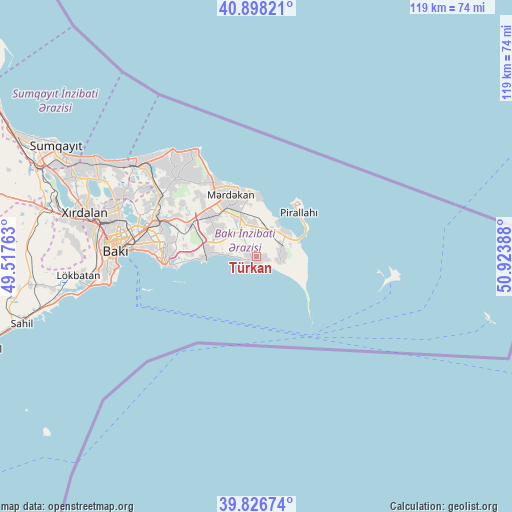
Türkan GPS coordinates[2]
40° 21' 52.56" North, 50° 13' 14.7" East
| Map corner | latitude | longitude |
|---|---|---|
| Upper-left | 40.89821°, | 49.51763° |
| Center: | 40.3646°, | 50.22075° |
| Lower-right: | 39.82674°, | 50.92388° |
| Map W x H: | 119.1×119.1 km | = 74×74mi |
| max Lat: | 41.75259° ⇑57.3% North |
| Türkan: | 40.3646° |
| min Lat: | ⇓42.7% South 38.45598° |
| min Long | Türkan | max Long |
| 44.84846° | 50.22075° | 50.84003° |
| W 97.8%⇐ | ⇒2.2% E |
Elevation
Elevation of Türkan is -17 m = -56 ft, and this is 400 m = 1312 ft below average elevation for this country.
| Max E: |
2211 m = 7254 ft | 92.4% |
| Avg. | 383 m = 1257 ft | |
| Türkan | -17 m = -56 ft | |
Min E: |
-26 m = -85 ft | 7.6% |
See also: Azerbaijan elevation on elevation.city.
Geographical zone
Türkan is located in North temperate zone (between Tropic of Cancer and the Arctic Circle). Distance of this Northern Tropic circle is 1882.2 km =1169.5 mi to South.| Distance of | km | miles | from Türkan |
|---|---|---|---|
| North Pole | 5518.9 | 3429.3 | to North |
| Arctic Circle | 2913.1 | 1810.1 | to North |
| Tropic Cancer | 1882.2 | 1169.5 | to South |
| Equator | 4488.1 | 2788.8 | to South |


Nearby cities:
15 places around Türkan: (largest is in red/bold)
• Amirdzhan
21.2 km =13.2 mi,  288°
288°
• Bakıxanov
22.3 km =13.9 mi, 285°
• Biny Selo
14.8 km =9.2 mi,  310°
310°
• Buzovna
19.4 km =12.1 mi,  332°
332°
• Gyurgyan
10.5 km =6.5 mi,  69°
69°
• Hövsan
11.5 km =7.1 mi,  275°
275°
• Mardakan
15.6 km =9.7 mi,  335°
335°
• Maştağa
25.8 km =16 mi,  315°
315°
• Pirallahı
14.7 km =9.1 mi,  36°
36°
• Qala
9.8 km =6.1 mi, 332°
• Qaraçuxur
21.2 km =13.2 mi, 279°
• Ramana
22.1 km =13.7 mi, 292°
• Sabunçu
24.7 km =15.3 mi, 290°
• Yeni Suraxanı
17.3 km =10.7 mi,  295°
295°
• Zyrya
6 km =3.7 mi,  88°
88°
Sources, notices
• [Note1] Compared only with cities in Azerbaijan existing in our database
• [Src1] Map data: © OpenStreetMap contributors (CC-BY-SA)
• [Src2] Other city data from geonames.org with taken over terms of usage.
• [Src3] Geographical zone / Annual Mean Temperature by Robert A. Rohde @ Wikipedia
