Mardakan geodata
Mardakan (Baki) is a populated place; located in Azerbaijan in Asia/Baku (GMT+4) time zone. With population of 15,267 people, there are 54 cities with bigger population in this country. Compared to other cities in Azerbaijan, 55.7% of cities are located further ↓South; 96.8% of cities are located further ←West and 84.9% of cities have higher elevation than Mardakan. Note1


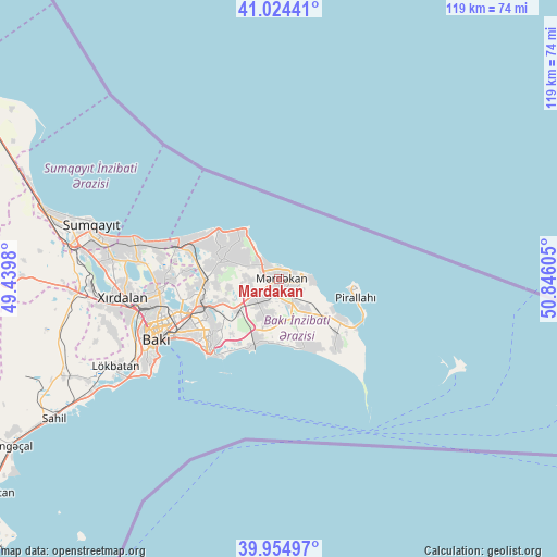
Mardakan GPS coordinates[2]
40° 29' 30.552" North, 50° 8' 34.512" East
| Map corner | latitude | longitude |
|---|---|---|
| Upper-left | 41.02441°, | 49.4398° |
| Center: | 40.49182°, | 50.14292° |
| Lower-right: | 39.95497°, | 50.84605° |
| Map W x H: | 118.9×118.9 km | = 73.9×73.9mi |
| max Lat: | 41.75259° ⇑44.3% North |
| Mardakan: | 40.49182° |
| min Lat: | ⇓55.7% South 38.45598° |
| min Long | Mardakan | max Long |
| 44.84846° | 50.14292° | 50.84003° |
| W 96.8%⇐ | ⇒3.2% E |
Elevation
Elevation of Mardakan is -4 m = -13 ft, and this is 387 m = 1270 ft below average elevation for this country.
| Max E: |
2211 m = 7254 ft | 84.9% |
| Avg. | 383 m = 1257 ft | |
| Mardakan | -4 m = -13 ft | |
Min E: |
-26 m = -85 ft | 15.1% |
See also: Azerbaijan elevation on elevation.city.
Geographical zone
Mardakan is located in North temperate zone (between Tropic of Cancer and the Arctic Circle). Distance of this Northern Tropic circle is 1896.3 km =1178.3 mi to South.| Distance of | km | miles | from Mardakan |
|---|---|---|---|
| North Pole | 5504.8 | 3420.5 | to North |
| Arctic Circle | 2898.9 | 1801.3 | to North |
| Tropic Cancer | 1896.3 | 1178.3 | to South |
| Equator | 4502.3 | 2797.6 | to South |


Nearby cities:
15 places around Mardakan: (largest is in red/bold)
• Amirdzhan
15.3 km =9.5 mi,  241°
241°
• Bakıxanov
17 km =10.6 mi, 241°
• Bilajer
11.9 km =7.4 mi,  312°
312°
• Biny Selo
6.6 km =4.1 mi,  226°
226°
• Buzovna
3.9 km =2.4 mi,  321°
321°
• Hövsan
13.9 km =8.6 mi,  200°
200°
• Maştağa
12.3 km =7.6 mi,  290°
290°
• Nardaran
13.6 km =8.5 mi,  301°
301°
• Pirallahı
15.6 km =9.7 mi,  98°
98°
• Qala
5.9 km =3.7 mi,  159°
159°
• Ramana
14.8 km =9.2 mi,  248°
248°
• Sabunçu
17.4 km =10.8 mi, 251°
• Türkan
15.6 km =9.7 mi, 155°
• Yeni Suraxanı
11.3 km =7 mi, 232°
• Zabrat
17.1 km =10.6 mi,  264°
264°
Sources, notices
• [Note1] Compared only with cities in Azerbaijan existing in our database
• [Src1] Map data: © OpenStreetMap contributors (CC-BY-SA)
• [Src2] Other city data from geonames.org with taken over terms of usage.
• [Src3] Geographical zone / Annual Mean Temperature by Robert A. Rohde @ Wikipedia
