Pirallahı geodata
Pirallahı (Baki) is a populated place; located in Azerbaijan in Asia/Baku (GMT+4) time zone. With population of 13,435 people, there are 59 cities with bigger population in this country. Compared to other cities in Azerbaijan, 54.1% of cities are located further ↓South; 98.9% of cities are located further ←West and 93.5% of cities have higher elevation than Pirallahı. Note1


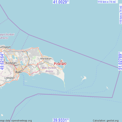
Pirallahı GPS coordinates[2]
40° 28' 12.468" North, 50° 19' 29.136" East
| Map corner | latitude | longitude |
|---|---|---|
| Upper-left | 41.0029°, | 49.62164° |
| Center: | 40.47013°, | 50.32476° |
| Lower-right: | 39.9331°, | 51.02789° |
| Map W x H: | 119×118.9 km | = 73.9×73.9mi |
| max Lat: | 41.75259° ⇑45.9% North |
| Pirallahı: | 40.47013° |
| min Lat: | ⇓54.1% South 38.45598° |
| min Long | Pirallahı | max Long |
| 44.84846° | 50.32476° | 50.84003° |
| W 98.9%⇐ | ⇒1.1% E |
Elevation
Elevation of Pirallahı is -19 m = -62 ft, and this is 402 m = 1319 ft below average elevation for this country.
| Max E: |
2211 m = 7254 ft | 93.5% |
| Avg. | 383 m = 1257 ft | |
| Pirallahı | -19 m = -62 ft | |
Min E: |
-26 m = -85 ft | 6.5% |
See also: Azerbaijan elevation on elevation.city.
Geographical zone
Pirallahı is located in North temperate zone (between Tropic of Cancer and the Arctic Circle). Distance of this Northern Tropic circle is 1893.9 km =1176.8 mi to South.| Distance of | km | miles | from Pirallahı |
|---|---|---|---|
| North Pole | 5507.2 | 3422 | to North |
| Arctic Circle | 2901.3 | 1802.8 | to North |
| Tropic Cancer | 1893.9 | 1176.8 | to South |
| Equator | 4499.9 | 2796.1 | to South |


Nearby cities:
15 places around Pirallahı: (largest is in red/bold)
• Amirdzhan
29.3 km =18.2 mi,  260°
260°
• Bilajer
26.3 km =16.3 mi,  293°
293°
• Biny Selo
20.2 km =12.6 mi, 263°
• Buzovna
18.6 km =11.6 mi, 286°
• Gyurgyan
8.2 km =5.1 mi,  172°
172°
• Hövsan
22.9 km =14.2 mi,  242°
242°
• Mardakan
15.6 km =9.7 mi,  278°
278°
• Maştağa
27.7 km =17.2 mi, 283°
• Nardaran
28.6 km =17.8 mi, 289°
• Qala
13.6 km =8.5 mi, 257°
• Qaraçuxur
30.8 km =19.1 mi,  254°
254°
• Ramana
29.3 km =18.2 mi, 263°
• Türkan
14.7 km =9.1 mi,  216°
216°
• Yeni Suraxanı
24.8 km =15.4 mi, 259°
• Zyrya
11.9 km =7.4 mi,  193°
193°
Sources, notices
• [Note1] Compared only with cities in Azerbaijan existing in our database
• [Src1] Map data: © OpenStreetMap contributors (CC-BY-SA)
• [Src2] Other city data from geonames.org with taken over terms of usage.
• [Src3] Geographical zone / Annual Mean Temperature by Robert A. Rohde @ Wikipedia
