Pālang geodata
Pālang (Dhaka) is a populated place; located in Bangladesh in Asia/Dhaka (GMT+6) time zone. With population of 67,652 people, there are 49 cities with bigger population in this country. Compared to other cities in Bangladesh, 65% of cities are located further ↑North; 60.7% of cities are located further ←West and 70.1% of cities have higher elevation than Pālang. Note1


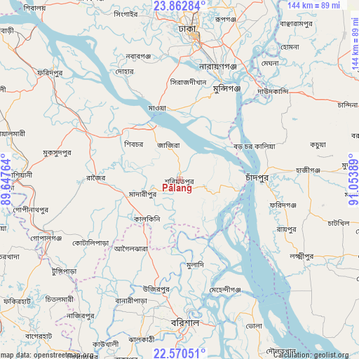
Pālang GPS coordinates[2]
23° 13' 5.664" North, 90° 21' 2.736" East
| Map corner | latitude | longitude |
|---|---|---|
| Upper-left | 23.86284°, | 89.64764° |
| Center: | 23.21824°, | 90.35076° |
| Lower-right: | 22.57051°, | 91.05389° |
| Map W x H: | 143.7×143.7 km | = 89.3×89.3mi |
| max Lat: | 26.33338° ⇑65% North |
| Pālang: | 23.21824° |
| min Lat: | ⇓35% South 20.85829° |
| min Long | Pālang | max Long |
| 88.15638° | 90.35076° | 92.29773° |
| W 60.7%⇐ | ⇒39.3% E |
Elevation
Elevation of Pālang is 12 m = 39 ft, and this is 5.9 m = 19 ft below average elevation for this country.
| Max E: |
79 m = 259 ft | 70.1% |
| Avg. | 17.9 m = 59 ft | |
| Pālang | 12 m = 39 ft | |
Min E: |
2 m = 7 ft | 29.9% |
See also: Pālang elevation on elevation.city.
Geographical zone
Pālang is located in North Torrid zone (between Equator and Tropic of Cancer). Distance of this Northern Tropic circle is 24.3 km =15.1 mi to North.| Distance of | km | miles | from Pālang |
|---|---|---|---|
| North Pole | 7425.4 | 4613.9 | to North |
| Arctic Circle | 4819.5 | 2994.7 | to North |
| Tropic Cancer | 24.3 | 15.1 | to North |
| Equator | 2581.6 | 1604.1 | to South |


Nearby cities:
15 places around Pālang: (largest is in red/bold)
• Azimpur
57 km =35.4 mi,  3°
3°
• Barisāl
57.1 km =35.5 mi,  178°
178°
• Char Bhadrāsan
16.2 km =10.1 mi,  308°
308°
• Dhaka
55 km =34.2 mi,  6°
6°
• Dohār
46.8 km =29.1 mi,  332°
332°
• Gaurnadi
30.1 km =18.7 mi,  205°
205°
• Hājīganj
51.7 km =32.1 mi,  85°
85°
• Lakshmīpur
57.7 km =35.9 mi,  121°
121°
• Mehendiganj
47.6 km =29.6 mi,  157°
157°
• Mādārīpur
15.4 km =9.6 mi,  250°
250°
• Nārāyanganj
46.6 km =29 mi,  19°
19°
• Rāipur
47.1 km =29.3 mi, 115°
• Rāmganj
52.7 km =32.7 mi,  104°
104°
• Sonārgaon
55.1 km =34.2 mi,  29°
29°
• Tungipāra
57.9 km =36 mi,  232°
232°
Sources, notices
• [Note1] Compared only with cities in Bangladesh existing in our database
• [Src1] Map data: © OpenStreetMap contributors (CC-BY-SA)
• [Src2] Other city data from geonames.org with taken over terms of usage.
• [Src3] Geographical zone / Annual Mean Temperature by Robert A. Rohde @ Wikipedia
