Bājitpur geodata
Bājitpur (Dhaka) is a populated place; located in Bangladesh in Asia/Dhaka (GMT+6) time zone. With population of 34,560 people, there are 91 cities with bigger population in this country. Compared to other cities in Bangladesh, 65% of cities are located further ↓South; 80.3% of cities are located further ←West and 56.4% of cities have higher elevation than Bājitpur. Note1
Administrative division(s):
- Level 1: Dhaka
- Level 2: Kishoregonj
- Level 3: Bajitpur
- Level 4: Paurashava


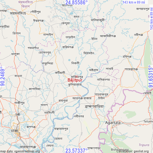
Bājitpur GPS coordinates[2]
24° 12' 58.428" North, 90° 57' 0.072" East
| Map corner | latitude | longitude |
|---|---|---|
| Upper-left | 24.85586°, | 90.2469° |
| Center: | 24.21623°, | 90.95002° |
| Lower-right: | 23.57337°, | 91.65315° |
| Map W x H: | 142.6×142.6 km | = 88.6×88.6mi |
| max Lat: | 26.33338° ⇑35% North |
| Bājitpur: | 24.21623° |
| min Lat: | ⇓65% South 20.85829° |
| min Long | Bājitpur | max Long |
| 88.15638° | 90.95002° | 92.29773° |
| W 80.3%⇐ | ⇒19.7% E |
Elevation
Elevation of Bājitpur is 14 m = 46 ft, and this is 3.9 m = 13 ft below average elevation for this country.
| Max E: |
79 m = 259 ft | 56.4% |
| Avg. | 17.9 m = 59 ft | |
| Bājitpur | 14 m = 46 ft | |
Min E: |
2 m = 7 ft | 43.6% |
See also: Bangladesh elevation on elevation.city.
Geographical zone
Bājitpur is located in North temperate zone (between Tropic of Cancer and the Arctic Circle). Distance of this Northern Tropic circle is 86.7 km =53.9 mi to South.| Distance of | km | miles | from Bājitpur |
|---|---|---|---|
| North Pole | 7314.5 | 4545 | to North |
| Arctic Circle | 4708.6 | 2925.8 | to North |
| Tropic Cancer | 86.7 | 53.9 | to South |
| Equator | 2692.6 | 1673.1 | to South |


Nearby cities:
15 places around Bājitpur: (largest is in red/bold)
• Azimpur
78.8 km =49 mi,  226°
226°
• Baniachang
53.3 km =33.1 mi,  50°
50°
• Bhairab Bāzār
18.4 km =11.4 mi,  171°
171°
• Dhaka
78.8 km =49 mi,  224°
224°
• Gafargaon
46.4 km =28.8 mi,  301°
301°
• Habiganj
50.3 km =31.3 mi,  68°
68°
• Kishorganj
30 km =18.6 mi,  325°
325°
• Nabīnagar
36.6 km =22.7 mi,  177°
177°
• Narsingdi
40.2 km =25 mi, 215°
• Netrakona
77.5 km =48.2 mi,  343°
343°
• Nārāyanganj
81 km =50.3 mi,  214°
214°
• Paltan
76.2 km =47.3 mi, 225°
• Sakhipur
80 km =49.7 mi,  278°
278°
• Sonārgaon
71.5 km =44.4 mi, 208°
• Tungi
66.3 km =41.2 mi,  237°
237°
Sources, notices
• [Note1] Compared only with cities in Bangladesh existing in our database
• [Src1] Map data: © OpenStreetMap contributors (CC-BY-SA)
• [Src2] Other city data from geonames.org with taken over terms of usage.
• [Src3] Geographical zone / Annual Mean Temperature by Robert A. Rohde @ Wikipedia
