Baniachang geodata
Baniachang (Sylhet) is a populated place; located in Bangladesh in Asia/Dhaka (GMT+6) time zone. With population of 37,807 people, there are 87 cities with bigger population in this country. Compared to other cities in Bangladesh, 74.4% of cities are located further ↓South; 84.6% of cities are located further ←West and 56.4% of cities have higher elevation than Baniachang. Note1
Administrative division(s):
- Level 1: Sylhet
- Level 2: Habiganj
- Level 3: Baniachong
- Level 4: Uttar Purba Baniachang


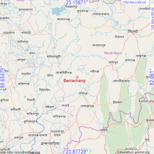
Baniachang GPS coordinates[2]
24° 31' 7.068" North, 91° 21' 28.332" East
| Map corner | latitude | longitude |
|---|---|---|
| Upper-left | 25.15671°, | 90.65475° |
| Center: | 24.51863°, | 91.35787° |
| Lower-right: | 23.87729°, | 92.061° |
| Map W x H: | 142.3×142.3 km | = 88.4×88.4mi |
| max Lat: | 26.33338° ⇑25.6% North |
| Baniachang: | 24.51863° |
| min Lat: | ⇓74.4% South 20.85829° |
| min Long | Baniachang | max Long |
| 88.15638° | 91.35787° | 92.29773° |
| W 84.6%⇐ | ⇒15.4% E |
Elevation
Elevation of Baniachang is 14 m = 46 ft, and this is 3.9 m = 13 ft below average elevation for this country.
| Max E: |
79 m = 259 ft | 56.4% |
| Avg. | 17.9 m = 59 ft | |
| Baniachang | 14 m = 46 ft | |
Min E: |
2 m = 7 ft | 43.6% |
See also: Bangladesh elevation on elevation.city.
Geographical zone
Baniachang is located in North temperate zone (between Tropic of Cancer and the Arctic Circle). Distance of this Northern Tropic circle is 120.3 km =74.8 mi to South.| Distance of | km | miles | from Baniachang |
|---|---|---|---|
| North Pole | 7280.8 | 4524.1 | to North |
| Arctic Circle | 4675 | 2904.9 | to North |
| Tropic Cancer | 120.3 | 74.8 | to South |
| Equator | 2726.2 | 1694 | to South |


Nearby cities:
15 places around Baniachang: (largest is in red/bold)
• Bhairab Bāzār
64.7 km =40.2 mi,  216°
216°
• Bājitpur
53.3 km =33.1 mi,  230°
230°
• Chhātak
65.8 km =40.9 mi,  28°
28°
• Gafargaon
81.5 km =50.6 mi,  263°
263°
• Habiganj
16.3 km =10.1 mi,  160°
160°
• Jahedpur
45.8 km =28.5 mi,  40°
40°
• Kishorganj
58.8 km =36.5 mi, 261°
• Maulavi Bāzār
41.9 km =26 mi,  94°
94°
• Muktāgācha
114.6 km =71.2 mi,  283°
283°
• Mymensingh
99.7 km =62 mi,  285°
285°
• Nabīnagar
80.5 km =50 mi,  209°
209°
• Narsingdi
92.7 km =57.6 mi, 224°
• Netrakona
75.4 km =46.9 mi,  302°
302°
• Purbadhala
89.8 km =55.8 mi, 301°
• Sylhet
67 km =41.6 mi,  50°
50°
Sources, notices
• [Note1] Compared only with cities in Bangladesh existing in our database
• [Src1] Map data: © OpenStreetMap contributors (CC-BY-SA)
• [Src2] Other city data from geonames.org with taken over terms of usage.
• [Src3] Geographical zone / Annual Mean Temperature by Robert A. Rohde @ Wikipedia
