Habiganj geodata
Habiganj (Sylhet) is a populated place; located in Bangladesh in Asia/Dhaka (GMT+6) time zone. With population of 88,760 people, there are 40 cities with bigger population in this country. Compared to other cities in Bangladesh, 69.2% of cities are located further ↓South; 86.3% of cities are located further ←West and 50.4% of cities have lower elevation than Habiganj. Note1
Administrative division(s):
- Level 1: Sylhet
- Level 2: Habiganj
- Level 3: Habiganj Sadar Upazila
- Level 4: Paurashava


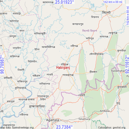
Habiganj GPS coordinates[2]
24° 22' 49.584" North, 91° 24' 46.764" East
| Map corner | latitude | longitude |
|---|---|---|
| Upper-left | 25.01923°, | 90.70987° |
| Center: | 24.38044°, | 91.41299° |
| Lower-right: | 23.7384°, | 92.11612° |
| Map W x H: | 142.4×142.4 km | = 88.5×88.5mi |
| max Lat: | 26.33338° ⇑30.8% North |
| Habiganj: | 24.38044° |
| min Lat: | ⇓69.2% South 20.85829° |
| min Long | Habiganj | max Long |
| 88.15638° | 91.41299° | 92.29773° |
| W 86.3%⇐ | ⇒13.7% E |
Elevation
Elevation of Habiganj is 15 m = 49 ft, and this is 2.9 m = 10 ft below average elevation for this country.
| Max E: |
79 m = 259 ft | 49.6% |
| Avg. | 17.9 m = 59 ft | |
| Habiganj | 15 m = 49 ft | |
Min E: |
2 m = 7 ft | 50.4% |
See also: Habiganj elevation on elevation.city.
Geographical zone
Habiganj is located in North temperate zone (between Tropic of Cancer and the Arctic Circle). Distance of this Northern Tropic circle is 104.9 km =65.2 mi to South.| Distance of | km | miles | from Habiganj |
|---|---|---|---|
| North Pole | 7296.2 | 4533.6 | to North |
| Arctic Circle | 4690.3 | 2914.4 | to North |
| Tropic Cancer | 104.9 | 65.2 | to South |
| Equator | 2710.9 | 1684.5 | to South |


Nearby cities:
15 places around Habiganj: (largest is in red/bold)
• Baniachang
16.3 km =10.1 mi,  340°
340°
• Bhairab Bāzār
57.4 km =35.7 mi,  230°
230°
• Bājitpur
50.3 km =31.3 mi,  248°
248°
• Chhātak
77.6 km =48.2 mi,  19°
19°
• Comilla
104.7 km =65.1 mi,  192°
192°
• Gafargaon
86.7 km =53.9 mi,  273°
273°
• Jahedpur
55.8 km =34.7 mi,  25°
25°
• Kishorganj
64.1 km =39.8 mi,  275°
275°
• Maulavi Bāzār
38.2 km =23.7 mi,  71°
71°
• Mymensingh
110 km =68.4 mi,  292°
292°
• Nabīnagar
71 km =44.1 mi,  219°
219°
• Narsingdi
87 km =54.1 mi, 234°
• Netrakona
88.9 km =55.2 mi,  308°
308°
• Purbadhala
103.1 km =64.1 mi, 307°
• Sylhet
74 km =46 mi,  38°
38°
Sources, notices
• [Note1] Compared only with cities in Bangladesh existing in our database
• [Src1] Map data: © OpenStreetMap contributors (CC-BY-SA)
• [Src2] Other city data from geonames.org with taken over terms of usage.
• [Src3] Geographical zone / Annual Mean Temperature by Robert A. Rohde @ Wikipedia
