Gafargaon geodata
Gafargaon (Mymensingh Division) is a populated place; located in Bangladesh in Asia/Dhaka (GMT+6) time zone. With population of 34,177 people, there are 93 cities with bigger population in this country. Compared to other cities in Bangladesh, 70.9% of cities are located further ↓South; 68.4% of cities are located further ←West and 57.3% of cities have lower elevation than Gafargaon. Note1
Administrative division(s):
- Level 1: Mymensingh Division
- Level 2: Mymensingh
- Level 3: Gaffargaon
- Level 4: Saltia


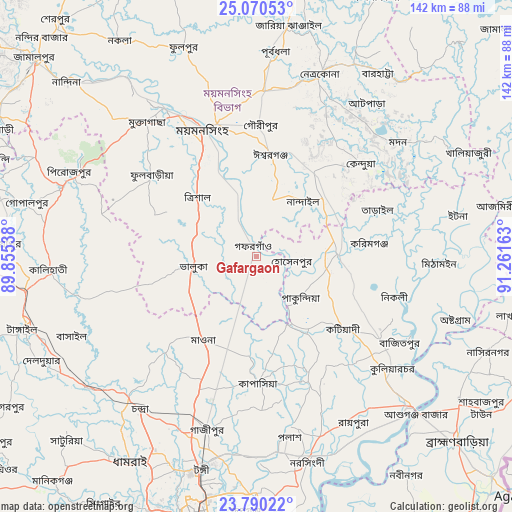
Gafargaon GPS coordinates[2]
24° 25' 55.2" North, 90° 33' 30.6" East
| Map corner | latitude | longitude |
|---|---|---|
| Upper-left | 25.07053°, | 89.85538° |
| Center: | 24.432°, | 90.5585° |
| Lower-right: | 23.79022°, | 91.26163° |
| Map W x H: | 142.4×142.4 km | = 88.5×88.5mi |
| max Lat: | 26.33338° ⇑29.1% North |
| Gafargaon: | 24.432° |
| min Lat: | ⇓70.9% South 20.85829° |
| min Long | Gafargaon | max Long |
| 88.15638° | 90.5585° | 92.29773° |
| W 68.4%⇐ | ⇒31.6% E |
Elevation
Elevation of Gafargaon is 16 m = 52 ft, and this is 1.9 m = 6 ft below average elevation for this country.
| Max E: |
79 m = 259 ft | 42.7% |
| Avg. | 17.9 m = 59 ft | |
| Gafargaon | 16 m = 52 ft | |
Min E: |
2 m = 7 ft | 57.3% |
See also: Bangladesh elevation on elevation.city.
Geographical zone
Gafargaon is located in North temperate zone (between Tropic of Cancer and the Arctic Circle). Distance of this Northern Tropic circle is 110.7 km =68.8 mi to South.| Distance of | km | miles | from Gafargaon |
|---|---|---|---|
| North Pole | 7290.5 | 4530.1 | to North |
| Arctic Circle | 4684.6 | 2910.9 | to North |
| Tropic Cancer | 110.7 | 68.8 | to South |
| Equator | 2716.6 | 1688 | to South |


Nearby cities:
15 places around Gafargaon: (largest is in red/bold)
• Azimpur
80 km =49.7 mi,  192°
192°
• Bhairab Bāzār
59.8 km =37.2 mi,  134°
134°
• Bājitpur
46.4 km =28.8 mi,  121°
121°
• Kishorganj
22.7 km =14.1 mi,  87°
87°
• Mirzāpur
59.3 km =36.8 mi,  231°
231°
• Muktāgācha
47.9 km =29.8 mi,  320°
320°
• Mymensingh
39.2 km =24.4 mi,  336°
336°
• Nabīnagar
73.4 km =45.6 mi,  145°
145°
• Narsingdi
58.9 km =36.6 mi,  164°
164°
• Netrakona
53.1 km =33 mi,  18°
18°
• Paltan
78.7 km =48.9 mi, 190°
• Purbadhala
56.7 km =35.2 mi,  4°
4°
• Sakhipur
41.3 km =25.7 mi,  252°
252°
• Tungi
62.1 km =38.6 mi, 194°
• Tāngāil
68.1 km =42.3 mi, 252°
Sources, notices
• [Note1] Compared only with cities in Bangladesh existing in our database
• [Src1] Map data: © OpenStreetMap contributors (CC-BY-SA)
• [Src2] Other city data from geonames.org with taken over terms of usage.
• [Src3] Geographical zone / Annual Mean Temperature by Robert A. Rohde @ Wikipedia
