Zedelgem geodata
Zedelgem (Flanders) is a populated place; located in Belgium in Europe/Brussels (GMT+2) time zone. With population of 21,968 people, there are 103 cities with bigger population in this country. Compared to other cities in Belgium, 85% of cities are located further ↓South; 94% of cities are located further →East and 88.4% of cities have higher elevation than Zedelgem. Note1
Administrative division(s):
- Level 1: Flanders
- Level 2: Provincie West-Vlaanderen
- Level 3: Arrondissement Brugge
- Level 4: Zedelgem


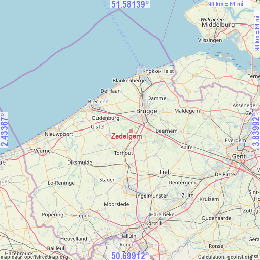
Zedelgem GPS coordinates[2]
51° 8' 32.496" North, 3° 8' 12.48" East
| Map corner | latitude | longitude |
|---|---|---|
| Upper-left | 51.58139°, | 2.43367° |
| Center: | 51.14236°, | 3.1368° |
| Lower-right: | 50.69912°, | 3.83992° |
| Map W x H: | 98.1×98.1 km | = 61×61mi |
| max Lat: | 51.46791° ⇑15% North |
| Zedelgem: | 51.14236° |
| min Lat: | ⇓85% South 49.53771° |
| min Long | Zedelgem | max Long |
| 2.59368° | 3.1368° | 6.25749° |
| W 6%⇐ | ⇒94% E |
Elevation
Elevation of Zedelgem is 9 m = 30 ft, and this is 90.5 m = 297 ft below average elevation for this country.
| Max E: |
582 m = 1909 ft | 88.4% |
| Avg. | 99.5 m = 326 ft | |
| Zedelgem | 9 m = 30 ft | |
Min E: |
1 m = 3 ft | 11.6% |
See also: Belgium elevation on elevation.city.
Geographical zone
Zedelgem is located in North temperate zone (between Tropic of Cancer and the Arctic Circle). Distance of this North polar circle is 1714.7 km =1065.5 mi to North.| Distance of | km | miles | from Zedelgem |
|---|---|---|---|
| North Pole | 4320.6 | 2684.7 | to North |
| Arctic Circle | 1714.7 | 1065.5 | to North |
| Tropic Cancer | 3080.6 | 1914.2 | to South |
| Equator | 5686.5 | 3533.4 | to South |


Nearby cities:
15 places around Zedelgem: (largest is in red/bold)
• Beernem
14.1 km =8.8 mi,  91°
91°
• Bredene
15.2 km =9.4 mi,  312°
312°
• Brugge
9.6 km =6 mi,  39°
39°
• Gistel
12.2 km =7.6 mi,  277°
277°
• Ichtegem
9.9 km =6.2 mi,  238°
238°
• Jabbeke
5.5 km =3.4 mi,  323°
323°
• Koekelare
12.5 km =7.8 mi, 242°
• Kortemark
14.2 km =8.8 mi,  208°
208°
• Lichtervelde
12.2 km =7.6 mi,  175°
175°
• Oostkamp
6.7 km =4.2 mi,  78°
78°
• Oudenburg
10.6 km =6.6 mi,  296°
296°
• Sint-Kruis
11.2 km =7 mi, 44°
• Torhout
8.9 km =5.5 mi,  196°
196°
• Wingene
13.4 km =8.3 mi,  134°
134°
• Zuienkerke
13.7 km =8.5 mi,  5°
5°
Sources, notices
• [Note1] Compared only with cities in Belgium existing in our database
• [Src1] Map data: © OpenStreetMap contributors (CC-BY-SA)
• [Src2] Other city data from geonames.org with taken over terms of usage.
• [Src3] Geographical zone / Annual Mean Temperature by Robert A. Rohde @ Wikipedia
