Brugge geodata
Brugge (Flanders) is a populated place; located in Belgium in Europe/Brussels (GMT+2) time zone. With population of 116,709 people, there are 5 cities with bigger population in this country. Compared to other cities in Belgium, 91% of cities are located further ↓South; 92.6% of cities are located further →East and 80.3% of cities have higher elevation than Brugge. Note1
Administrative division(s):
- Level 1: Flanders
- Level 2: Provincie West-Vlaanderen
- Level 3: Arrondissement Brugge
- Level 4: Brugge


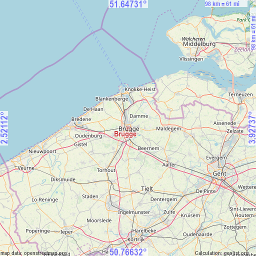
Brugge GPS coordinates[2]
51° 12' 32.112" North, 3° 13' 27.264" East
| Map corner | latitude | longitude |
|---|---|---|
| Upper-left | 51.64731°, | 2.52112° |
| Center: | 51.20892°, | 3.22424° |
| Lower-right: | 50.76632°, | 3.92737° |
| Map W x H: | 98×98 km | = 60.9×60.9mi |
| max Lat: | 51.46791° ⇑9% North |
| Brugge: | 51.20892° |
| min Lat: | ⇓91% South 49.53771° |
| min Long | Brugge | max Long |
| 2.59368° | 3.22424° | 6.25749° |
| W 7.4%⇐ | ⇒92.6% E |
Elevation
Elevation of Brugge is 13 m = 43 ft, and this is 86.5 m = 284 ft below average elevation for this country.
| Max E: |
582 m = 1909 ft | 80.3% |
| Avg. | 99.5 m = 326 ft | |
| Brugge | 13 m = 43 ft | |
Min E: |
1 m = 3 ft | 19.7% |
See also: Brugge elevation on elevation.city.
Geographical zone
Brugge is located in North temperate zone (between Tropic of Cancer and the Arctic Circle). Distance of this North polar circle is 1707.3 km =1060.9 mi to North.| Distance of | km | miles | from Brugge |
|---|---|---|---|
| North Pole | 4313.2 | 2680.1 | to North |
| Arctic Circle | 1707.3 | 1060.9 | to North |
| Tropic Cancer | 3088 | 1918.8 | to South |
| Equator | 5693.9 | 3538 | to South |


Nearby cities:
15 places around Brugge: (largest is in red/bold)
• Beernem
11.1 km =6.9 mi,  133°
133°
• Blankenberge
13.2 km =8.2 mi,  331°
331°
• Damme
6.2 km =3.9 mi,  40°
40°
• De Haan
15 km =9.3 mi,  298°
298°
• Jabbeke
9.9 km =6.2 mi,  252°
252°
• Knesselare
15.3 km =9.5 mi,  120°
120°
• Knokke-Heist
16 km =9.9 mi,  10°
10°
• Maldegem
15.4 km =9.6 mi,  90°
90°
• Oostkamp
6.1 km =3.8 mi,  175°
175°
• Oudenburg
15.8 km =9.8 mi,  260°
260°
• Sint-Kruis
1.8 km =1.1 mi,  72°
72°
• Wenduine
14 km =8.7 mi,  315°
315°
• Zedelgem
9.6 km =6 mi,  219°
219°
• Zeebrugge
13.7 km =8.5 mi,  347°
347°
• Zuienkerke
7.9 km =4.9 mi, 322°
In other languages:
- In Spanish: Brujas
- In France: Bruges
- In German: Brügge
- In Italian: Bruges
- In Russian: Брюгге
- In Chinese: 布吕赫
Sources, notices
• [Note1] Compared only with cities in Belgium existing in our database
• [Src1] Map data: © OpenStreetMap contributors (CC-BY-SA)
• [Src2] Other city data from geonames.org with taken over terms of usage.
• [Src3] Geographical zone / Annual Mean Temperature by Robert A. Rohde @ Wikipedia
