Zuienkerke geodata
Zuienkerke (Flanders) is a populated place; located in Belgium in Europe/Brussels (GMT+2) time zone. With population of 2,736 people, there are 516 cities with bigger population in this country. Compared to other cities in Belgium, 95.3% of cities are located further ↓South; 93.7% of cities are located further →East and 99.5% of cities have higher elevation than Zuienkerke. Note1
Administrative division(s):
- Level 1: Flanders
- Level 2: Provincie West-Vlaanderen
- Level 3: Arrondissement Brugge
- Level 4: Zuienkerke


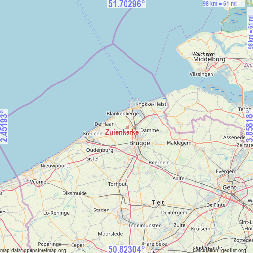
Zuienkerke GPS coordinates[2]
51° 15' 54.396" North, 3° 9' 18.216" East
| Map corner | latitude | longitude |
|---|---|---|
| Upper-left | 51.70296°, | 2.45193° |
| Center: | 51.26511°, | 3.15506° |
| Lower-right: | 50.82304°, | 3.85818° |
| Map W x H: | 97.8×97.8 km | = 60.8×60.8mi |
| max Lat: | 51.46791° ⇑4.7% North |
| Zuienkerke: | 51.26511° |
| min Lat: | ⇓95.3% South 49.53771° |
| min Long | Zuienkerke | max Long |
| 2.59368° | 3.15506° | 6.25749° |
| W 6.3%⇐ | ⇒93.7% E |
Elevation
Elevation of Zuienkerke is 3 m = 10 ft, and this is 96.5 m = 317 ft below average elevation for this country.
| Max E: |
582 m = 1909 ft | 99.5% |
| Avg. | 99.5 m = 326 ft | |
| Zuienkerke | 3 m = 10 ft | |
Min E: |
1 m = 3 ft | 0.5% |
See also: Belgium elevation on elevation.city.
Geographical zone
Zuienkerke is located in North temperate zone (between Tropic of Cancer and the Arctic Circle). Distance of this North polar circle is 1701 km =1057 mi to North.| Distance of | km | miles | from Zuienkerke |
|---|---|---|---|
| North Pole | 4306.9 | 2676.2 | to North |
| Arctic Circle | 1701 | 1057 | to North |
| Tropic Cancer | 3094.2 | 1922.6 | to South |
| Equator | 5700.1 | 3541.9 | to South |


Nearby cities:
15 places around Zuienkerke: (largest is in red/bold)
• Blankenberge
5.6 km =3.5 mi,  343°
343°
• Bredene
12.9 km =8 mi,  254°
254°
• Brugge
7.9 km =4.9 mi,  142°
142°
• Damme
8.9 km =5.5 mi,  99°
99°
• De Haan
8.4 km =5.2 mi,  275°
275°
• Gistel
18 km =11.2 mi,  227°
227°
• Jabbeke
10.3 km =6.4 mi,  206°
206°
• Knokke-Heist
12.2 km =7.6 mi,  39°
39°
• Oostkamp
13.4 km =8.3 mi,  156°
156°
• Ostend
16.8 km =10.4 mi, 250°
• Oudenburg
14 km =8.7 mi, 230°
• Sint-Kruis
8.7 km =5.4 mi,  130°
130°
• Wenduine
6.3 km =3.9 mi,  306°
306°
• Zedelgem
13.7 km =8.5 mi,  185°
185°
• Zeebrugge
7.3 km =4.5 mi,  14°
14°
Sources, notices
• [Note1] Compared only with cities in Belgium existing in our database
• [Src1] Map data: © OpenStreetMap contributors (CC-BY-SA)
• [Src2] Other city data from geonames.org with taken over terms of usage.
• [Src3] Geographical zone / Annual Mean Temperature by Robert A. Rohde @ Wikipedia
