Zulte geodata
Zulte (Flanders) is a populated place; located in Belgium in Europe/Brussels (GMT+2) time zone. With population of 14,670 people, there are 189 cities with bigger population in this country. Compared to other cities in Belgium, 62.6% of cities are located further ↓South; 87.2% of cities are located further →East and 83.8% of cities have higher elevation than Zulte. Note1
Administrative division(s):
- Level 1: Flanders
- Level 2: Provincie Oost-Vlaanderen
- Level 3: Arrondissement Gent
- Level 4: Zulte


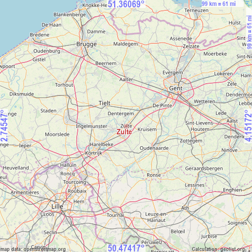
Zulte GPS coordinates[2]
50° 55' 10.344" North, 3° 26' 54.924" East
| Map corner | latitude | longitude |
|---|---|---|
| Upper-left | 51.36069°, | 2.74547° |
| Center: | 50.91954°, | 3.44859° |
| Lower-right: | 50.47417°, | 4.15172° |
| Map W x H: | 98.6×98.6 km | = 61.3×61.3mi |
| max Lat: | 51.46791° ⇑37.4% North |
| Zulte: | 50.91954° |
| min Lat: | ⇓62.6% South 49.53771° |
| min Long | Zulte | max Long |
| 2.59368° | 3.44859° | 6.25749° |
| W 12.8%⇐ | ⇒87.2% E |
Elevation
Elevation of Zulte is 11 m = 36 ft, and this is 88.5 m = 290 ft below average elevation for this country.
| Max E: |
582 m = 1909 ft | 83.8% |
| Avg. | 99.5 m = 326 ft | |
| Zulte | 11 m = 36 ft | |
Min E: |
1 m = 3 ft | 16.2% |
See also: Belgium elevation on elevation.city.
Geographical zone
Zulte is located in North temperate zone (between Tropic of Cancer and the Arctic Circle). Distance of this North polar circle is 1739.5 km =1080.9 mi to North.| Distance of | km | miles | from Zulte |
|---|---|---|---|
| North Pole | 4345.3 | 2700 | to North |
| Arctic Circle | 1739.5 | 1080.9 | to North |
| Tropic Cancer | 3055.8 | 1898.8 | to South |
| Equator | 5661.7 | 3518 | to South |


Nearby cities:
15 places around Zulte: (largest is in red/bold)
• Anzegem
9.4 km =5.8 mi,  167°
167°
• Deerlijk
9.9 km =6.2 mi,  221°
221°
• Deinze
9 km =5.6 mi,  39°
39°
• Dentergem
5.5 km =3.4 mi,  335°
335°
• Harelbeke
12.2 km =7.6 mi,  233°
233°
• Ingelmunster
13.5 km =8.4 mi,  270°
270°
• Kruishoutem
5.8 km =3.6 mi,  110°
110°
• Kuurne
13.9 km =8.6 mi,  236°
236°
• Meulebeke
11.8 km =7.3 mi,  287°
287°
• Nazareth
11 km =6.8 mi,  67°
67°
• Oostrozebeke
7.8 km =4.8 mi, 271°
• Oudenaarde
13.5 km =8.4 mi,  123°
123°
• Tielt
12.3 km =7.6 mi,  316°
316°
• Waregem
3.7 km =2.3 mi,  203°
203°
• Wielsbeke
6.1 km =3.8 mi,  249°
249°
Sources, notices
• [Note1] Compared only with cities in Belgium existing in our database
• [Src1] Map data: © OpenStreetMap contributors (CC-BY-SA)
• [Src2] Other city data from geonames.org with taken over terms of usage.
• [Src3] Geographical zone / Annual Mean Temperature by Robert A. Rohde @ Wikipedia
