Tellin geodata
Tellin (Wallonia) is a populated place; located in Belgium in Europe/Brussels (GMT+2) time zone. With population of 2,353 people, there are 526 cities with bigger population in this country. Compared to other cities in Belgium, 94% of cities are located further ↑North; 73.6% of cities are located further ←West and 90.1% of cities have lower elevation than Tellin. Note1
Administrative division(s):
- Level 1: Wallonia
- Level 2: Province du Luxembourg
- Level 3: Arrondissement de Neufchâteau
- Level 4: Tellin


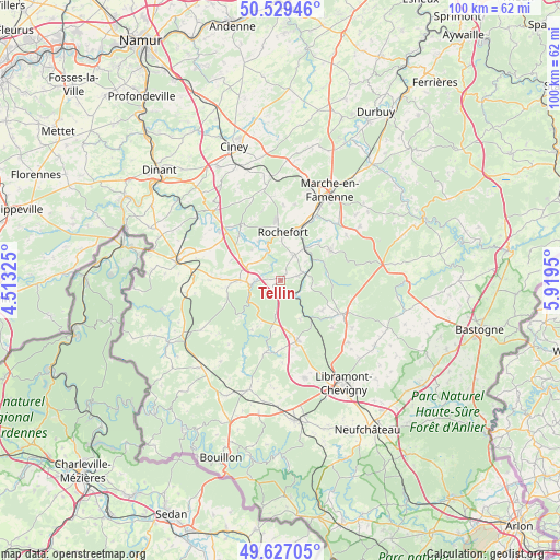
Tellin GPS coordinates[2]
50° 4' 49.368" North, 5° 12' 58.968" East
| Map corner | latitude | longitude |
|---|---|---|
| Upper-left | 50.52946°, | 4.51325° |
| Center: | 50.08038°, | 5.21638° |
| Lower-right: | 49.62705°, | 5.9195° |
| Map W x H: | 100.3×100.3 km | = 62.3×62.3mi |
| max Lat: | 51.46791° ⇑94% North |
| Tellin: | 50.08038° |
| min Lat: | ⇓6% South 49.53771° |
| min Long | Tellin | max Long |
| 2.59368° | 5.21638° | 6.25749° |
| W 73.6%⇐ | ⇒26.4% E |
Elevation
Elevation of Tellin is 263 m = 863 ft, and this is 163.5 m = 536 ft above average elevation for this country.
| Max E: |
582 m = 1909 ft | 9.9% |
| Tellin | 263 m 863 ft | |
| Avg. | 99.5 m = 326 ft | |
Min E: |
1 m = 3 ft | 90.1% |
See also: Belgium elevation on elevation.city.
Geographical zone
Tellin is located in North temperate zone (between Tropic of Cancer and the Arctic Circle). Distance of this North polar circle is 1832.8 km =1138.8 mi to North.| Distance of | km | miles | from Tellin |
|---|---|---|---|
| North Pole | 4438.6 | 2758 | to North |
| Arctic Circle | 1832.8 | 1138.8 | to North |
| Tropic Cancer | 2962.5 | 1840.8 | to South |
| Equator | 5568.4 | 3460 | to South |


Nearby cities:
15 places around Tellin: (largest is in red/bold)
• Beauraing
18.9 km =11.7 mi,  280°
280°
• Bertrix
25.1 km =15.6 mi,  173°
173°
• Bièvre
21.1 km =13.1 mi,  222°
222°
• Daverdisse
9.6 km =6 mi,  227°
227°
• Gedinne
22.9 km =14.2 mi,  240°
240°
• Houyet
19 km =11.8 mi,  308°
308°
• Libin
11.4 km =7.1 mi, 165°
• Marche-en-Famenne
18.7 km =11.6 mi,  29°
29°
• Nassogne
10.5 km =6.5 mi,  59°
59°
• Paliseul
20.5 km =12.7 mi,  196°
196°
• Rochefort
9.2 km =5.7 mi,  2°
2°
• Saint-Hubert
12.7 km =7.9 mi,  117°
117°
• Sainte-Ode
22.7 km =14.1 mi,  107°
107°
• Tenneville
22.4 km =13.9 mi,  85°
85°
• Wellin
7.3 km =4.5 mi,  270°
270°
Sources, notices
• [Note1] Compared only with cities in Belgium existing in our database
• [Src1] Map data: © OpenStreetMap contributors (CC-BY-SA)
• [Src2] Other city data from geonames.org with taken over terms of usage.
• [Src3] Geographical zone / Annual Mean Temperature by Robert A. Rohde @ Wikipedia
