Wellin geodata
Wellin (Wallonia) is a populated place; located in Belgium in Europe/Brussels (GMT+2) time zone. With population of 2,937 people, there are 509 cities with bigger population in this country. Compared to other cities in Belgium, 93.9% of cities are located further ↑North; 70.6% of cities are located further ←West and 88.1% of cities have lower elevation than Wellin. Note1
Administrative division(s):
- Level 1: Wallonia
- Level 2: Province du Luxembourg
- Level 3: Arrondissement de Neufchâteau
- Level 4: Wellin


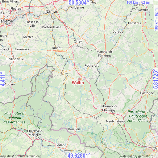
Wellin GPS coordinates[2]
50° 4' 52.788" North, 5° 6' 50.868" East
| Map corner | latitude | longitude |
|---|---|---|
| Upper-left | 50.5304°, | 4.411° |
| Center: | 50.08133°, | 5.11413° |
| Lower-right: | 49.62801°, | 5.81725° |
| Map W x H: | 100.3×100.3 km | = 62.3×62.3mi |
| max Lat: | 51.46791° ⇑93.9% North |
| Wellin: | 50.08133° |
| min Lat: | ⇓6.1% South 49.53771° |
| min Long | Wellin | max Long |
| 2.59368° | 5.11413° | 6.25749° |
| W 70.6%⇐ | ⇒29.4% E |
Elevation
Elevation of Wellin is 250 m = 820 ft, and this is 150.5 m = 494 ft above average elevation for this country.
| Max E: |
582 m = 1909 ft | 11.9% |
| Wellin | 250 m 820 ft | |
| Avg. | 99.5 m = 326 ft | |
Min E: |
1 m = 3 ft | 88.1% |
See also: Belgium elevation on elevation.city.
Geographical zone
Wellin is located in North temperate zone (between Tropic of Cancer and the Arctic Circle). Distance of this North polar circle is 1832.7 km =1138.8 mi to North.| Distance of | km | miles | from Wellin |
|---|---|---|---|
| North Pole | 4438.5 | 2758 | to North |
| Arctic Circle | 1832.7 | 1138.8 | to North |
| Tropic Cancer | 2962.6 | 1840.9 | to South |
| Equator | 5568.5 | 3460.1 | to South |


Nearby cities:
15 places around Wellin: (largest is in red/bold)
• Beauraing
11.8 km =7.3 mi,  285°
285°
• Bièvre
17.1 km =10.6 mi,  204°
204°
• Ciney
23.7 km =14.7 mi,  357°
357°
• Daverdisse
6.6 km =4.1 mi,  177°
177°
• Dinant
24.4 km =15.2 mi,  323°
323°
• Gedinne
16.9 km =10.5 mi,  228°
228°
• Hastière-Lavaux
25.7 km =16 mi,  306°
306°
• Houyet
13.9 km =8.6 mi,  326°
326°
• Libin
15.1 km =9.4 mi,  137°
137°
• Marche-en-Famenne
23 km =14.3 mi,  45°
45°
• Nassogne
17.1 km =10.6 mi,  72°
72°
• Paliseul
19.8 km =12.3 mi, 175°
• Rochefort
11.9 km =7.4 mi,  40°
40°
• Saint-Hubert
19.5 km =12.1 mi,  108°
108°
• Tellin
7.3 km =4.5 mi,  90°
90°
Sources, notices
• [Note1] Compared only with cities in Belgium existing in our database
• [Src1] Map data: © OpenStreetMap contributors (CC-BY-SA)
• [Src2] Other city data from geonames.org with taken over terms of usage.
• [Src3] Geographical zone / Annual Mean Temperature by Robert A. Rohde @ Wikipedia
