Bièvre geodata
Bièvre (Wallonia) is a populated place; located in Belgium in Europe/Brussels (GMT+2) time zone. With population of 3,207 people, there are 501 cities with bigger population in this country. Compared to other cities in Belgium, 95.8% of cities are located further ↑North; 66.8% of cities are located further ←West and 95.5% of cities have lower elevation than Bièvre. Note1
Administrative division(s):
- Level 1: Wallonia
- Level 2: Province de Namur
- Level 3: Arrondissement de Dinant
- Level 4: Bièvre


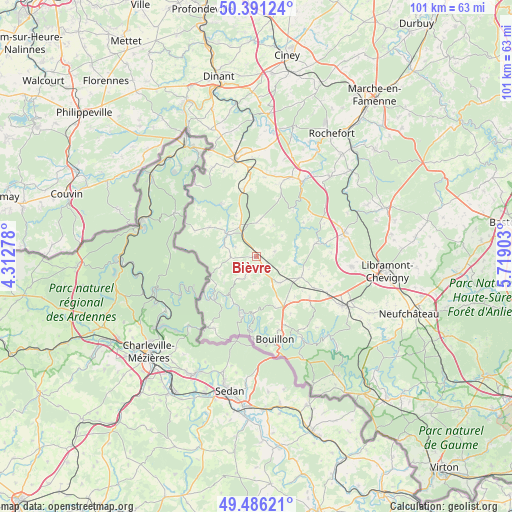
Bièvre GPS coordinates[2]
49° 56' 27.06" North, 5° 0' 57.276" East
| Map corner | latitude | longitude |
|---|---|---|
| Upper-left | 50.39124°, | 4.31278° |
| Center: | 49.94085°, | 5.01591° |
| Lower-right: | 49.48621°, | 5.71903° |
| Map W x H: | 100.6×100.6 km | = 62.5×62.5mi |
| max Lat: | 51.46791° ⇑95.8% North |
| Bièvre: | 49.94085° |
| min Lat: | ⇓4.2% South 49.53771° |
| min Long | Bièvre | max Long |
| 2.59368° | 5.01591° | 6.25749° |
| W 66.8%⇐ | ⇒33.2% E |
Elevation
Elevation of Bièvre is 368 m = 1207 ft, and this is 268.5 m = 881 ft above average elevation for this country.
| Max E: |
582 m = 1909 ft | 4.5% |
| Bièvre | 368 m 1207 ft | |
| Avg. | 99.5 m = 326 ft | |
Min E: |
1 m = 3 ft | 95.5% |
See also: Belgium elevation on elevation.city.
Geographical zone
Bièvre is located in North temperate zone (between Tropic of Cancer and the Arctic Circle). Distance of this North polar circle is 1848.3 km =1148.5 mi to North.| Distance of | km | miles | from Bièvre |
|---|---|---|---|
| North Pole | 4454.2 | 2767.7 | to North |
| Arctic Circle | 1848.3 | 1148.5 | to North |
| Tropic Cancer | 2947 | 1831.2 | to South |
| Equator | 5552.9 | 3450.4 | to South |


Nearby cities:
15 places around Bièvre: (largest is in red/bold)
• Beauraing
19.3 km =12 mi,  347°
347°
• Bertrix
19.6 km =12.2 mi,  118°
118°
• Bouillon
16.8 km =10.4 mi,  167°
167°
• Daverdisse
11.6 km =7.2 mi,  39°
39°
• Doische
29.3 km =18.2 mi,  316°
316°
• Gedinne
7.2 km =4.5 mi,  307°
307°
• Herbeumont
23.8 km =14.8 mi,  138°
138°
• Houyet
27.3 km =17 mi,  358°
358°
• Libin
17.8 km =11.1 mi,  75°
75°
• Nassogne
31.3 km =19.4 mi,  48°
48°
• Paliseul
9.5 km =5.9 mi, 115°
• Rochefort
28.7 km =17.8 mi,  30°
30°
• Saint-Hubert
27.3 km =17 mi,  69°
69°
• Tellin
21.1 km =13.1 mi, 42°
• Wellin
17.1 km =10.6 mi,  24°
24°
Sources, notices
• [Note1] Compared only with cities in Belgium existing in our database
• [Src1] Map data: © OpenStreetMap contributors (CC-BY-SA)
• [Src2] Other city data from geonames.org with taken over terms of usage.
• [Src3] Geographical zone / Annual Mean Temperature by Robert A. Rohde @ Wikipedia
