Philippeville geodata
Philippeville (Wallonia) is a seat of a third-order administrative division; located in Belgium in Europe/Brussels (GMT+2) time zone. With population of 8,051 people, there are 362 cities with bigger population in this country. Compared to other cities in Belgium, 91.5% of cities are located further ↑North; 51.3% of cities are located further →East and 91.7% of cities have lower elevation than Philippeville. Note1
Administrative division(s):
- Level 1: Wallonia
- Level 2: Province de Namur
- Level 3: Arrondissement de Philippeville
- Level 4: Philippeville


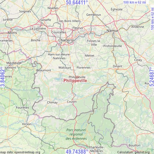
Philippeville GPS coordinates[2]
50° 11' 46.032" North, 4° 32' 37.464" East
| Map corner | latitude | longitude |
|---|---|---|
| Upper-left | 50.64411°, | 3.84062° |
| Center: | 50.19612°, | 4.54374° |
| Lower-right: | 49.74388°, | 5.24687° |
| Map W x H: | 100.1×100.1 km | = 62.2×62.2mi |
| max Lat: | 51.46791° ⇑91.5% North |
| Philippeville: | 50.19612° |
| min Lat: | ⇓8.5% South 49.53771° |
| min Long | Philippeville | max Long |
| 2.59368° | 4.54374° | 6.25749° |
| W 48.7%⇐ | ⇒51.3% E |
Elevation
Elevation of Philippeville is 290 m = 951 ft, and this is 190.5 m = 625 ft above average elevation for this country.
| Max E: |
582 m = 1909 ft | 8.3% |
| Philippeville | 290 m 951 ft | |
| Avg. | 99.5 m = 326 ft | |
Min E: |
1 m = 3 ft | 91.7% |
See also: Belgium elevation on elevation.city.
Geographical zone
Philippeville is located in North temperate zone (between Tropic of Cancer and the Arctic Circle). Distance of this North polar circle is 1819.9 km =1130.8 mi to North.| Distance of | km | miles | from Philippeville |
|---|---|---|---|
| North Pole | 4425.8 | 2750.1 | to North |
| Arctic Circle | 1819.9 | 1130.8 | to North |
| Tropic Cancer | 2975.4 | 1848.8 | to South |
| Equator | 5581.3 | 3468.1 | to South |


Nearby cities:
15 places around Philippeville: (largest is in red/bold)
• Aiseau
24.2 km =15 mi,  7°
7°
• Beaumont
22.1 km =13.7 mi,  281°
281°
• Cerfontaine
9.9 km =6.2 mi,  253°
253°
• Chimay
23 km =14.3 mi,  224°
224°
• Châtelet
23.1 km =14.4 mi,  357°
357°
• Couvin
16.3 km =10.1 mi,  192°
192°
• Doische
15.3 km =9.5 mi,  116°
116°
• Florennes
7.6 km =4.7 mi,  35°
35°
• Froidchapelle
16.2 km =10.1 mi, 251°
• Gerpinnes
15.8 km =9.8 mi, 355°
• Hastière-Lavaux
20.1 km =12.5 mi,  82°
82°
• La Bruyère
22.7 km =14.1 mi, 12°
• Mettet
16.3 km =10.1 mi,  31°
31°
• Onhaye
21.7 km =13.5 mi, 76°
• Walcourt
9.9 km =6.2 mi,  310°
310°
Sources, notices
• [Note1] Compared only with cities in Belgium existing in our database
• [Src1] Map data: © OpenStreetMap contributors (CC-BY-SA)
• [Src2] Other city data from geonames.org with taken over terms of usage.
• [Src3] Geographical zone / Annual Mean Temperature by Robert A. Rohde @ Wikipedia
