Mettet geodata
Mettet (Wallonia) is a populated place; located in Belgium in Europe/Brussels (GMT+2) time zone. With population of 12,014 people, there are 243 cities with bigger population in this country. Compared to other cities in Belgium, 88.3% of cities are located further ↑North; 53.8% of cities are located further ←West and 87% of cities have lower elevation than Mettet. Note1
Administrative division(s):
- Level 1: Wallonia
- Level 2: Province de Namur
- Level 3: Arrondissement de Namur
- Level 4: Mettet


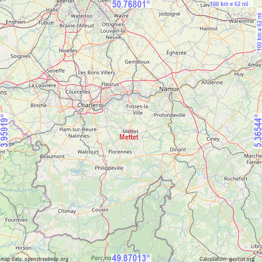
Mettet GPS coordinates[2]
50° 19' 16.284" North, 4° 39' 44.352" East
| Map corner | latitude | longitude |
|---|---|---|
| Upper-left | 50.76801°, | 3.95919° |
| Center: | 50.32119°, | 4.66232° |
| Lower-right: | 49.87013°, | 5.36544° |
| Map W x H: | 99.8×99.8 km | = 62×62mi |
| max Lat: | 51.46791° ⇑88.3% North |
| Mettet: | 50.32119° |
| min Lat: | ⇓11.7% South 49.53771° |
| min Long | Mettet | max Long |
| 2.59368° | 4.66232° | 6.25749° |
| W 53.8%⇐ | ⇒46.2% E |
Elevation
Elevation of Mettet is 241 m = 791 ft, and this is 141.5 m = 464 ft above average elevation for this country.
| Max E: |
582 m = 1909 ft | 13% |
| Mettet | 241 m 791 ft | |
| Avg. | 99.5 m = 326 ft | |
Min E: |
1 m = 3 ft | 87% |
See also: Belgium elevation on elevation.city.
Geographical zone
Mettet is located in North temperate zone (between Tropic of Cancer and the Arctic Circle). Distance of this North polar circle is 1806 km =1122.2 mi to North.| Distance of | km | miles | from Mettet |
|---|---|---|---|
| North Pole | 4411.9 | 2741.4 | to North |
| Arctic Circle | 1806 | 1122.2 | to North |
| Tropic Cancer | 2989.3 | 1857.5 | to South |
| Equator | 5595.2 | 3476.7 | to South |


Nearby cities:
15 places around Mettet: (largest is in red/bold)
• Aiseau
11.4 km =7.1 mi,  331°
331°
• Anhée
15.4 km =9.6 mi,  94°
94°
• Châtelet
13.2 km =8.2 mi,  313°
313°
• Farciennes
14.8 km =9.2 mi,  324°
324°
• Floreffe
14.4 km =8.9 mi,  28°
28°
• Florennes
8.7 km =5.4 mi,  207°
207°
• Fosses-la-Ville
8.6 km =5.3 mi,  16°
16°
• Gerpinnes
9.8 km =6.1 mi,  280°
280°
• Hastière-Lavaux
16.2 km =10.1 mi,  134°
134°
• La Bruyère
8.9 km =5.5 mi,  337°
337°
• Onhaye
15.5 km =9.6 mi,  124°
124°
• Philippeville
16.3 km =10.1 mi, 211°
• Profondeville
15.6 km =9.7 mi,  67°
67°
• Walcourt
17.6 km =10.9 mi,  244°
244°
• Yvoir
15.5 km =9.6 mi, 87°
Sources, notices
• [Note1] Compared only with cities in Belgium existing in our database
• [Src1] Map data: © OpenStreetMap contributors (CC-BY-SA)
• [Src2] Other city data from geonames.org with taken over terms of usage.
• [Src3] Geographical zone / Annual Mean Temperature by Robert A. Rohde @ Wikipedia
