Doische geodata
Doische (Wallonia) is a populated place; located in Belgium in Europe/Brussels (GMT+2) time zone. With population of 2,739 people, there are 515 cities with bigger population in this country. Compared to other cities in Belgium, 92.8% of cities are located further ↑North; 56.5% of cities are located further ←West and 78.2% of cities have lower elevation than Doische. Note1
Administrative division(s):
- Level 1: Wallonia
- Level 2: Province de Namur
- Level 3: Arrondissement de Philippeville
- Level 4: Doische


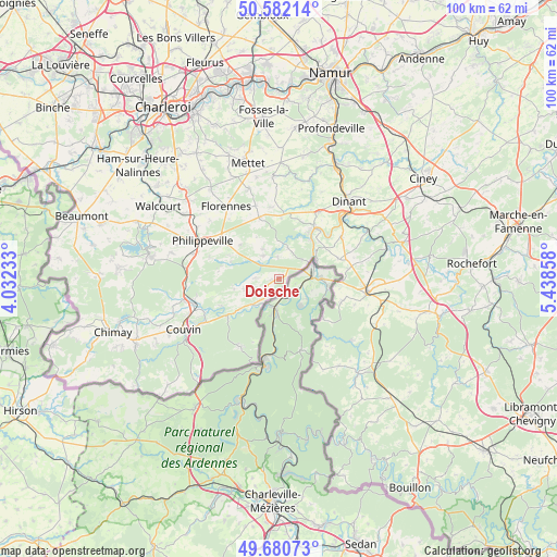
Doische GPS coordinates[2]
50° 8' 0.816" North, 4° 44' 7.62" East
| Map corner | latitude | longitude |
|---|---|---|
| Upper-left | 50.58214°, | 4.03233° |
| Center: | 50.13356°, | 4.73545° |
| Lower-right: | 49.68073°, | 5.43858° |
| Map W x H: | 100.2×100.2 km | = 62.3×62.3mi |
| max Lat: | 51.46791° ⇑92.8% North |
| Doische: | 50.13356° |
| min Lat: | ⇓7.2% South 49.53771° |
| min Long | Doische | max Long |
| 2.59368° | 4.73545° | 6.25749° |
| W 56.5%⇐ | ⇒43.5% E |
Elevation
Elevation of Doische is 167 m = 548 ft, and this is 67.5 m = 221 ft above average elevation for this country.
| Max E: |
582 m = 1909 ft | 21.8% |
| Doische | 167 m 548 ft | |
| Avg. | 99.5 m = 326 ft | |
Min E: |
1 m = 3 ft | 78.2% |
See also: Belgium elevation on elevation.city.
Geographical zone
Doische is located in North temperate zone (between Tropic of Cancer and the Arctic Circle). Distance of this North polar circle is 1826.8 km =1135.1 mi to North.| Distance of | km | miles | from Doische |
|---|---|---|---|
| North Pole | 4432.7 | 2754.4 | to North |
| Arctic Circle | 1826.8 | 1135.1 | to North |
| Tropic Cancer | 2968.4 | 1844.5 | to South |
| Equator | 5574.3 | 3463.7 | to South |


Nearby cities:
15 places around Doische: (largest is in red/bold)
• Anhée
22.1 km =13.7 mi,  27°
27°
• Beauraing
15.9 km =9.9 mi,  99°
99°
• Cerfontaine
23.5 km =14.6 mi,  280°
280°
• Couvin
19.4 km =12.1 mi,  242°
242°
• Dinant
18.7 km =11.6 mi,  42°
42°
• Florennes
16 km =9.9 mi,  324°
324°
• Gedinne
22.3 km =13.9 mi,  139°
139°
• Gerpinnes
27.1 km =16.8 mi,  326°
326°
• Hastière-Lavaux
11.4 km =7.1 mi, 33°
• Houyet
20.3 km =12.6 mi,  73°
73°
• Mettet
21.5 km =13.4 mi,  345°
345°
• Onhaye
14.1 km =8.8 mi, 31°
• Philippeville
15.3 km =9.5 mi,  296°
296°
• Walcourt
25.1 km =15.6 mi, 302°
• Yvoir
23.9 km =14.9 mi, 25°
Sources, notices
• [Note1] Compared only with cities in Belgium existing in our database
• [Src1] Map data: © OpenStreetMap contributors (CC-BY-SA)
• [Src2] Other city data from geonames.org with taken over terms of usage.
• [Src3] Geographical zone / Annual Mean Temperature by Robert A. Rohde @ Wikipedia
