Liedekerke geodata
Liedekerke (Flanders) is a populated place; located in Belgium in Europe/Brussels (GMT+2) time zone. With population of 11,980 people, there are 245 cities with bigger population in this country. Compared to other cities in Belgium, 56.5% of cities are located further ↓South; 72.6% of cities are located further →East and 67.3% of cities have higher elevation than Liedekerke. Note1
Administrative division(s):
- Level 1: Flanders
- Level 2: Provincie Vlaams-Brabant
- Level 3: Arrondissement Halle-Vilvoorde
- Level 4: Liedekerke


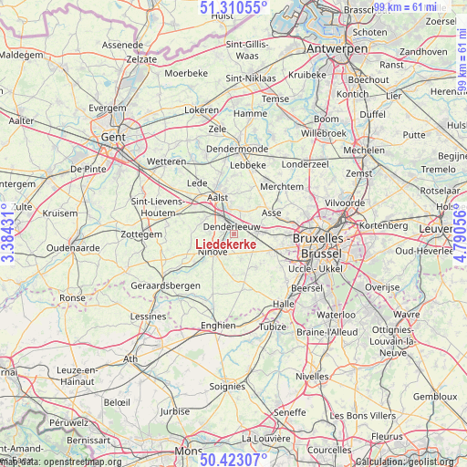
Liedekerke GPS coordinates[2]
50° 52' 8.112" North, 4° 5' 14.748" East
| Map corner | latitude | longitude |
|---|---|---|
| Upper-left | 51.31055°, | 3.38431° |
| Center: | 50.86892°, | 4.08743° |
| Lower-right: | 50.42307°, | 4.79056° |
| Map W x H: | 98.7×98.7 km | = 61.3×61.3mi |
| max Lat: | 51.46791° ⇑43.5% North |
| Liedekerke: | 50.86892° |
| min Lat: | ⇓56.5% South 49.53771° |
| min Long | Liedekerke | max Long |
| 2.59368° | 4.08743° | 6.25749° |
| W 27.4%⇐ | ⇒72.6% E |
Elevation
Elevation of Liedekerke is 24 m = 79 ft, and this is 75.5 m = 248 ft below average elevation for this country.
| Max E: |
582 m = 1909 ft | 67.3% |
| Avg. | 99.5 m = 326 ft | |
| Liedekerke | 24 m = 79 ft | |
Min E: |
1 m = 3 ft | 32.7% |
See also: Belgium elevation on elevation.city.
Geographical zone
Liedekerke is located in North temperate zone (between Tropic of Cancer and the Arctic Circle). Distance of this North polar circle is 1745.1 km =1084.4 mi to North.| Distance of | km | miles | from Liedekerke |
|---|---|---|---|
| North Pole | 4351 | 2703.6 | to North |
| Arctic Circle | 1745.1 | 1084.4 | to North |
| Tropic Cancer | 3050.2 | 1895.3 | to South |
| Equator | 5656.1 | 3514.5 | to South |


Nearby cities:
15 places around Liedekerke: (largest is in red/bold)
• Aalst
8.3 km =5.2 mi,  333°
333°
• Asse
9 km =5.6 mi,  59°
59°
• Denderleeuw
2 km =1.2 mi,  335°
335°
• Dilbeek
12.3 km =7.6 mi,  100°
100°
• Gooik
8.5 km =5.3 mi,  167°
167°
• Haaltert
7.4 km =4.6 mi,  304°
304°
• Lede
13 km =8.1 mi, 326°
• Ledeberg
2.8 km =1.7 mi, 174°
• Lennik
8.5 km =5.3 mi,  141°
141°
• Merchtem
13.7 km =8.5 mi,  47°
47°
• Ninove
6.3 km =3.9 mi,  223°
223°
• Opwijk
12.9 km =8 mi,  31°
31°
• Pepingen
13.2 km =8.2 mi,  157°
157°
• Sint-Martens-Lennik
8.6 km =5.3 mi, 137°
• Ternat
5.6 km =3.5 mi,  92°
92°
Sources, notices
• [Note1] Compared only with cities in Belgium existing in our database
• [Src1] Map data: © OpenStreetMap contributors (CC-BY-SA)
• [Src2] Other city data from geonames.org with taken over terms of usage.
• [Src3] Geographical zone / Annual Mean Temperature by Robert A. Rohde @ Wikipedia
