Opwijk geodata
Opwijk (Flanders) is a populated place; located in Belgium in Europe/Brussels (GMT+2) time zone. With population of 12,045 people, there are 242 cities with bigger population in this country. Compared to other cities in Belgium, 67.3% of cities are located further ↓South; 68.8% of cities are located further →East and 70% of cities have higher elevation than Opwijk. Note1
Administrative division(s):
- Level 1: Flanders
- Level 2: Provincie Vlaams-Brabant
- Level 3: Arrondissement Halle-Vilvoorde
- Level 4: Opwijk


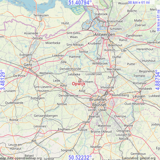
Opwijk GPS coordinates[2]
50° 58' 2.064" North, 4° 11' 3.912" East
| Map corner | latitude | longitude |
|---|---|---|
| Upper-left | 51.40794°, | 3.48129° |
| Center: | 50.96724°, | 4.18442° |
| Lower-right: | 50.52232°, | 4.88754° |
| Map W x H: | 98.5×98.5 km | = 61.2×61.2mi |
| max Lat: | 51.46791° ⇑32.7% North |
| Opwijk: | 50.96724° |
| min Lat: | ⇓67.3% South 49.53771° |
| min Long | Opwijk | max Long |
| 2.59368° | 4.18442° | 6.25749° |
| W 31.2%⇐ | ⇒68.8% E |
Elevation
Elevation of Opwijk is 22 m = 72 ft, and this is 77.5 m = 254 ft below average elevation for this country.
| Max E: |
582 m = 1909 ft | 70% |
| Avg. | 99.5 m = 326 ft | |
| Opwijk | 22 m = 72 ft | |
Min E: |
1 m = 3 ft | 30% |
See also: Belgium elevation on elevation.city.
Geographical zone
Opwijk is located in North temperate zone (between Tropic of Cancer and the Arctic Circle). Distance of this North polar circle is 1734.1 km =1077.5 mi to North.| Distance of | km | miles | from Opwijk |
|---|---|---|---|
| North Pole | 4340 | 2696.8 | to North |
| Arctic Circle | 1734.1 | 1077.5 | to North |
| Tropic Cancer | 3061.1 | 1902.1 | to South |
| Equator | 5667 | 3521.3 | to South |


Nearby cities:
15 places around Opwijk: (largest is in red/bold)
• Aalst
11 km =6.8 mi,  251°
251°
• Asse
6.4 km =4 mi,  171°
171°
• Bever
10.8 km =6.7 mi,  121°
121°
• Buggenhout
5.5 km =3.4 mi,  12°
12°
• Denderleeuw
11.9 km =7.4 mi,  219°
219°
• Dendermonde
9 km =5.6 mi,  319°
319°
• Kapelle-op-den-Bos
13.4 km =8.3 mi,  69°
69°
• Lebbeke
5.4 km =3.4 mi, 320°
• Liedekerke
12.9 km =8 mi,  211°
211°
• Londerzeel
9.3 km =5.8 mi,  63°
63°
• Meise
10.4 km =6.5 mi,  107°
107°
• Merchtem
3.8 km =2.4 mi, 118°
• Sint-Amands
10.1 km =6.3 mi, 10°
• Ternat
11.3 km =7 mi,  186°
186°
• Wemmel
10.8 km =6.7 mi,  127°
127°
Sources, notices
• [Note1] Compared only with cities in Belgium existing in our database
• [Src1] Map data: © OpenStreetMap contributors (CC-BY-SA)
• [Src2] Other city data from geonames.org with taken over terms of usage.
• [Src3] Geographical zone / Annual Mean Temperature by Robert A. Rohde @ Wikipedia
