Merchtem geodata
Merchtem (Flanders) is a populated place; located in Belgium in Europe/Brussels (GMT+2) time zone. With population of 14,660 people, there are 190 cities with bigger population in this country. Compared to other cities in Belgium, 65.7% of cities are located further ↓South; 67.5% of cities are located further →East and 65.9% of cities have higher elevation than Merchtem. Note1
Administrative division(s):
- Level 1: Flanders
- Level 2: Provincie Vlaams-Brabant
- Level 3: Arrondissement Halle-Vilvoorde
- Level 4: Merchtem


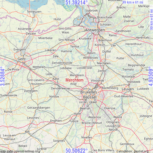
Merchtem GPS coordinates[2]
50° 57' 4.644" North, 4° 13' 55.092" East
| Map corner | latitude | longitude |
|---|---|---|
| Upper-left | 51.39214°, | 3.52884° |
| Center: | 50.95129°, | 4.23197° |
| Lower-right: | 50.50622°, | 4.93509° |
| Map W x H: | 98.5×98.5 km | = 61.2×61.2mi |
| max Lat: | 51.46791° ⇑34.3% North |
| Merchtem: | 50.95129° |
| min Lat: | ⇓65.7% South 49.53771° |
| min Long | Merchtem | max Long |
| 2.59368° | 4.23197° | 6.25749° |
| W 32.5%⇐ | ⇒67.5% E |
Elevation
Elevation of Merchtem is 25 m = 82 ft, and this is 74.5 m = 244 ft below average elevation for this country.
| Max E: |
582 m = 1909 ft | 65.9% |
| Avg. | 99.5 m = 326 ft | |
| Merchtem | 25 m = 82 ft | |
Min E: |
1 m = 3 ft | 34.1% |
See also: Belgium elevation on elevation.city.
Geographical zone
Merchtem is located in North temperate zone (between Tropic of Cancer and the Arctic Circle). Distance of this North polar circle is 1735.9 km =1078.6 mi to North.| Distance of | km | miles | from Merchtem |
|---|---|---|---|
| North Pole | 4341.8 | 2697.9 | to North |
| Arctic Circle | 1735.9 | 1078.6 | to North |
| Tropic Cancer | 3059.3 | 1901 | to South |
| Equator | 5665.3 | 3520.3 | to South |


Nearby cities:
15 places around Merchtem: (largest is in red/bold)
• Asse
5.1 km =3.2 mi,  207°
207°
• Bever
7.1 km =4.4 mi,  122°
122°
• Buggenhout
7.5 km =4.7 mi,  343°
343°
• Denderleeuw
13.2 km =8.2 mi,  236°
236°
• Dendermonde
12.6 km =7.8 mi,  313°
313°
• Dilbeek
11.6 km =7.2 mi,  170°
170°
• Grimbergen
10 km =6.2 mi,  101°
101°
• Kapelle-op-den-Bos
11.2 km =7 mi,  54°
54°
• Lebbeke
9 km =5.6 mi, 311°
• Londerzeel
7.7 km =4.8 mi,  39°
39°
• Meise
6.8 km =4.2 mi, 101°
• Opwijk
3.8 km =2.4 mi,  298°
298°
• Sint-Amands
11.8 km =7.3 mi,  352°
352°
• Ternat
10.5 km =6.5 mi, 205°
• Wemmel
7.1 km =4.4 mi,  132°
132°
Sources, notices
• [Note1] Compared only with cities in Belgium existing in our database
• [Src1] Map data: © OpenStreetMap contributors (CC-BY-SA)
• [Src2] Other city data from geonames.org with taken over terms of usage.
• [Src3] Geographical zone / Annual Mean Temperature by Robert A. Rohde @ Wikipedia
