Gooik geodata
Gooik (Flanders) is a populated place; located in Belgium in Europe/Brussels (GMT+2) time zone. With population of 8,957 people, there are 337 cities with bigger population in this country. Compared to other cities in Belgium, 50.2% of cities are located further ↑North; 71.3% of cities are located further →East and 57.2% of cities have higher elevation than Gooik. Note1
Administrative division(s):
- Level 1: Flanders
- Level 2: Provincie Vlaams-Brabant
- Level 3: Arrondissement Halle-Vilvoorde
- Level 4: Gooik


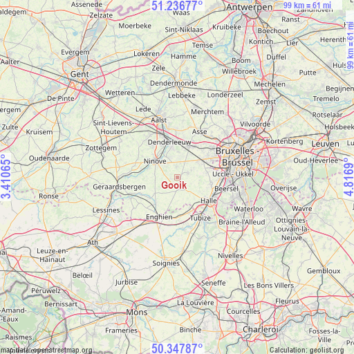
Gooik GPS coordinates[2]
50° 47' 39.948" North, 4° 6' 49.608" East
| Map corner | latitude | longitude |
|---|---|---|
| Upper-left | 51.23677°, | 3.41065° |
| Center: | 50.79443°, | 4.11378° |
| Lower-right: | 50.34787°, | 4.8169° |
| Map W x H: | 98.8×98.8 km | = 61.4×61.4mi |
| max Lat: | 51.46791° ⇑50.2% North |
| Gooik: | 50.79443° |
| min Lat: | ⇓49.8% South 49.53771° |
| min Long | Gooik | max Long |
| 2.59368° | 4.11378° | 6.25749° |
| W 28.7%⇐ | ⇒71.3% E |
Elevation
Elevation of Gooik is 39 m = 128 ft, and this is 60.5 m = 198 ft below average elevation for this country.
| Max E: |
582 m = 1909 ft | 57.2% |
| Avg. | 99.5 m = 326 ft | |
| Gooik | 39 m = 128 ft | |
Min E: |
1 m = 3 ft | 42.8% |
See also: Belgium elevation on elevation.city.
Geographical zone
Gooik is located in North temperate zone (between Tropic of Cancer and the Arctic Circle). Distance of this North polar circle is 1753.4 km =1089.5 mi to North.| Distance of | km | miles | from Gooik |
|---|---|---|---|
| North Pole | 4359.3 | 2708.7 | to North |
| Arctic Circle | 1753.4 | 1089.5 | to North |
| Tropic Cancer | 3041.9 | 1890.1 | to South |
| Equator | 5647.8 | 3509.4 | to South |


Nearby cities:
15 places around Gooik: (largest is in red/bold)
• Beersel
13.5 km =8.4 mi,  103°
103°
• Denderleeuw
10.4 km =6.5 mi,  345°
345°
• Dilbeek
11.9 km =7.4 mi,  59°
59°
• Galmaarden
11 km =6.8 mi,  245°
245°
• Halle
10.8 km =6.7 mi,  128°
128°
• Herne
9.6 km =6 mi,  215°
215°
• Ledeberg
5.7 km =3.5 mi,  343°
343°
• Lennik
3.8 km =2.4 mi, 64°
• Liedekerke
8.5 km =5.3 mi, 347°
• Ninove
7.2 km =4.5 mi,  301°
301°
• Pepingen
5.1 km =3.2 mi,  140°
140°
• Sint-Martens-Lennik
4.4 km =2.7 mi, 64°
• Sint-Pieters-Leeuw
9.3 km =5.8 mi, 100°
• Ternat
8.8 km =5.5 mi,  24°
24°
• Tubize
13.1 km =8.1 mi,  152°
152°
Sources, notices
• [Note1] Compared only with cities in Belgium existing in our database
• [Src1] Map data: © OpenStreetMap contributors (CC-BY-SA)
• [Src2] Other city data from geonames.org with taken over terms of usage.
• [Src3] Geographical zone / Annual Mean Temperature by Robert A. Rohde @ Wikipedia
