Asse geodata
Asse (Flanders) is a populated place; located in Belgium in Europe/Brussels (GMT+2) time zone. With population of 28,985 people, there are 66 cities with bigger population in this country. Compared to other cities in Belgium, 61.7% of cities are located further ↓South; 68.4% of cities are located further →East and 60.3% of cities have lower elevation than Asse. Note1
Administrative division(s):
- Level 1: Flanders
- Level 2: Provincie Vlaams-Brabant
- Level 3: Arrondissement Halle-Vilvoorde
- Level 4: Asse


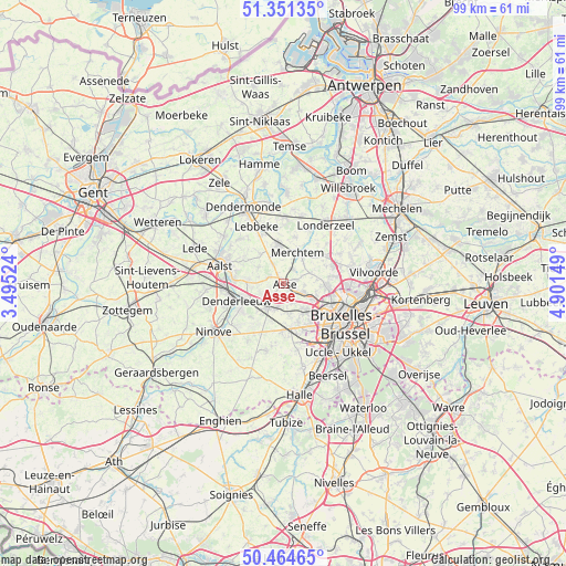
Asse GPS coordinates[2]
50° 54' 36.396" North, 4° 11' 54.096" East
| Map corner | latitude | longitude |
|---|---|---|
| Upper-left | 51.35135°, | 3.49524° |
| Center: | 50.91011°, | 4.19836° |
| Lower-right: | 50.46465°, | 4.90149° |
| Map W x H: | 98.6×98.6 km | = 61.3×61.3mi |
| max Lat: | 51.46791° ⇑38.3% North |
| Asse: | 50.91011° |
| min Lat: | ⇓61.7% South 49.53771° |
| min Long | Asse | max Long |
| 2.59368° | 4.19836° | 6.25749° |
| W 31.6%⇐ | ⇒68.4% E |
Elevation
Elevation of Asse is 81 m = 266 ft, and this is 18.5 m = 61 ft below average elevation for this country.
| Max E: |
582 m = 1909 ft | 39.7% |
| Avg. | 99.5 m = 326 ft | |
| Asse | 81 m = 266 ft | |
Min E: |
1 m = 3 ft | 60.3% |
See also: Belgium elevation on elevation.city.
Geographical zone
Asse is located in North temperate zone (between Tropic of Cancer and the Arctic Circle). Distance of this North polar circle is 1740.5 km =1081.5 mi to North.| Distance of | km | miles | from Asse |
|---|---|---|---|
| North Pole | 4346.4 | 2700.7 | to North |
| Arctic Circle | 1740.5 | 1081.5 | to North |
| Tropic Cancer | 3054.8 | 1898.2 | to South |
| Equator | 5660.7 | 3517.4 | to South |


Nearby cities:
15 places around Asse: (largest is in red/bold)
• Aalst
11.8 km =7.3 mi,  284°
284°
• Bever
8.3 km =5.2 mi,  84°
84°
• Buggenhout
11.8 km =7.3 mi,  1°
1°
• Denderleeuw
9 km =5.6 mi,  252°
252°
• Dilbeek
8.1 km =5 mi,  148°
148°
• Lebbeke
11.4 km =7.1 mi,  336°
336°
• Ledeberg
10.6 km =6.6 mi,  225°
225°
• Lennik
11.5 km =7.1 mi,  192°
192°
• Liedekerke
9 km =5.6 mi,  239°
239°
• Meise
9.6 km =6 mi,  70°
70°
• Merchtem
5.1 km =3.2 mi,  27°
27°
• Opwijk
6.4 km =4 mi,  351°
351°
• Sint-Martens-Lennik
11.1 km =6.9 mi, 190°
• Ternat
5.3 km =3.3 mi,  204°
204°
• Wemmel
7.6 km =4.7 mi,  91°
91°
Sources, notices
• [Note1] Compared only with cities in Belgium existing in our database
• [Src1] Map data: © OpenStreetMap contributors (CC-BY-SA)
• [Src2] Other city data from geonames.org with taken over terms of usage.
• [Src3] Geographical zone / Annual Mean Temperature by Robert A. Rohde @ Wikipedia
