Bertem geodata
Bertem (Flanders) is a populated place; located in Belgium in Europe/Brussels (GMT+2) time zone. With population of 9,215 people, there are 324 cities with bigger population in this country. Compared to other cities in Belgium, 56.1% of cities are located further ↓South; 52.2% of cities are located further ←West and 57.2% of cities have higher elevation than Bertem. Note1
Administrative division(s):
- Level 1: Flanders
- Level 2: Provincie Vlaams-Brabant
- Level 3: Arrondissement Leuven
- Level 4: Bertem


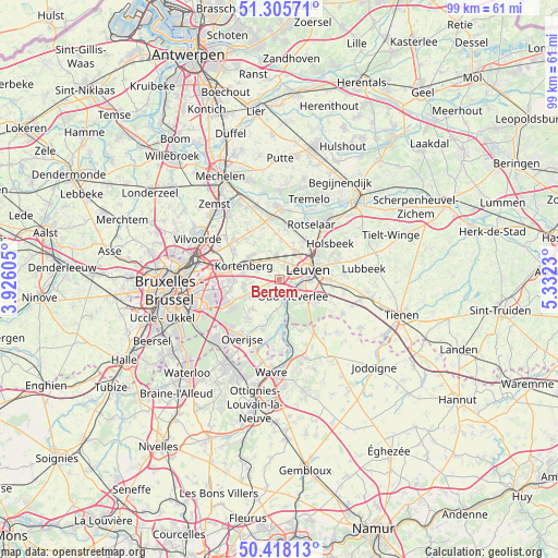
Bertem GPS coordinates[2]
50° 51' 50.508" North, 4° 37' 45.048" East
| Map corner | latitude | longitude |
|---|---|---|
| Upper-left | 51.30571°, | 3.92605° |
| Center: | 50.86403°, | 4.62918° |
| Lower-right: | 50.41813°, | 5.3323° |
| Map W x H: | 98.7×98.7 km | = 61.3×61.3mi |
| max Lat: | 51.46791° ⇑43.9% North |
| Bertem: | 50.86403° |
| min Lat: | ⇓56.1% South 49.53771° |
| min Long | Bertem | max Long |
| 2.59368° | 4.62918° | 6.25749° |
| W 52.2%⇐ | ⇒47.8% E |
Elevation
Elevation of Bertem is 39 m = 128 ft, and this is 60.5 m = 198 ft below average elevation for this country.
| Max E: |
582 m = 1909 ft | 57.2% |
| Avg. | 99.5 m = 326 ft | |
| Bertem | 39 m = 128 ft | |
Min E: |
1 m = 3 ft | 42.8% |
See also: Belgium elevation on elevation.city.
Geographical zone
Bertem is located in North temperate zone (between Tropic of Cancer and the Arctic Circle). Distance of this North polar circle is 1745.6 km =1084.7 mi to North.| Distance of | km | miles | from Bertem |
|---|---|---|---|
| North Pole | 4351.5 | 2703.9 | to North |
| Arctic Circle | 1745.6 | 1084.7 | to North |
| Tropic Cancer | 3049.6 | 1894.9 | to South |
| Equator | 5655.5 | 3514.2 | to South |


Nearby cities:
15 places around Bertem: (largest is in red/bold)
• Bierbeek
10 km =6.2 mi,  113°
113°
• Herent
5.7 km =3.5 mi,  30°
30°
• Holsbeek
11 km =6.8 mi,  54°
54°
• Huldenberg
8.9 km =5.5 mi,  201°
201°
• Kampenhout
10.3 km =6.4 mi,  327°
327°
• Kortenberg
6.7 km =4.2 mi,  295°
295°
• Kraainem
11.2 km =7 mi,  268°
268°
• Leuven
5.3 km =3.3 mi,  71°
71°
• Oud-Heverlee
4 km =2.5 mi,  142°
142°
• Overijse
12 km =7.5 mi,  213°
213°
• Rotselaar
11.6 km =7.2 mi, 31°
• Steenokkerzeel
10.3 km =6.4 mi,  305°
305°
• Tervuren
9.2 km =5.7 mi,  240°
240°
• Wezembeek-Oppem
9.9 km =6.2 mi,  253°
253°
• Zaventem
11.2 km =7 mi,  281°
281°
Sources, notices
• [Note1] Compared only with cities in Belgium existing in our database
• [Src1] Map data: © OpenStreetMap contributors (CC-BY-SA)
• [Src2] Other city data from geonames.org with taken over terms of usage.
• [Src3] Geographical zone / Annual Mean Temperature by Robert A. Rohde @ Wikipedia
