Mechelen geodata
Mechelen (Flanders) is a populated place; located in Belgium in Europe/Brussels (GMT+2) time zone. With population of 77,530 people, there are 11 cities with bigger population in this country. Compared to other cities in Belgium, 73.1% of cities are located further ↓South; 55.4% of cities are located further →East and 91% of cities have higher elevation than Mechelen. Note1
Administrative division(s):
- Level 1: Flanders
- Level 2: Provincie Antwerpen
- Level 3: Arrondissement Mechelen
- Level 4: Mechelen


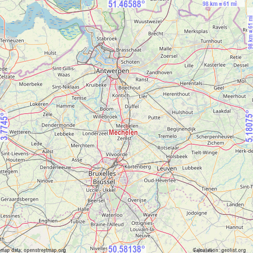
Mechelen GPS coordinates[2]
51° 1' 32.664" North, 4° 28' 39.432" East
| Map corner | latitude | longitude |
|---|---|---|
| Upper-left | 51.46588°, | 3.7745° |
| Center: | 51.02574°, | 4.47762° |
| Lower-right: | 50.58138°, | 5.18075° |
| Map W x H: | 98.3×98.3 km | = 61.1×61.1mi |
| max Lat: | 51.46791° ⇑26.9% North |
| Mechelen: | 51.02574° |
| min Lat: | ⇓73.1% South 49.53771° |
| min Long | Mechelen | max Long |
| 2.59368° | 4.47762° | 6.25749° |
| W 44.6%⇐ | ⇒55.4% E |
Elevation
Elevation of Mechelen is 8 m = 26 ft, and this is 91.5 m = 300 ft below average elevation for this country.
| Max E: |
582 m = 1909 ft | 91% |
| Avg. | 99.5 m = 326 ft | |
| Mechelen | 8 m = 26 ft | |
Min E: |
1 m = 3 ft | 9% |
See also: Mechelen elevation on elevation.city.
Geographical zone
Mechelen is located in North temperate zone (between Tropic of Cancer and the Arctic Circle). Distance of this North polar circle is 1727.6 km =1073.5 mi to North.| Distance of | km | miles | from Mechelen |
|---|---|---|---|
| North Pole | 4333.5 | 2692.7 | to North |
| Arctic Circle | 1727.6 | 1073.5 | to North |
| Tropic Cancer | 3067.6 | 1906.1 | to South |
| Equator | 5673.5 | 3525.3 | to South |


Nearby cities:
15 places around Mechelen: (largest is in red/bold)
• Bonheiden
4.9 km =3 mi,  94°
94°
• Boom
10.5 km =6.5 mi,  315°
315°
• Boortmeerbeek
8.5 km =5.3 mi,  127°
127°
• Duffel
8.1 km =5 mi,  15°
15°
• Kampenhout
10.6 km =6.6 mi,  151°
151°
• Kapelle-op-den-Bos
8.2 km =5.1 mi,  257°
257°
• Keerbergen
11.3 km =7 mi,  103°
103°
• Kontich
12 km =7.5 mi,  349°
349°
• Lint
11.3 km =7 mi,  6°
6°
• Putte
11.3 km =7 mi,  74°
74°
• Rumst
7.3 km =4.5 mi,  328°
328°
• Sint-Katelijne-Waver
6.1 km =3.8 mi,  41°
41°
• Vilvoorde
11.4 km =7.1 mi,  197°
197°
• Willebroek
9.1 km =5.7 mi,  295°
295°
• Zemst
4.9 km =3 mi,  193°
193°
In other languages:
- In Spanish: Malinas
- In France: Malines
- In German: Mecheln
- In Italian: Malines
- In Russian: Мехелен
- In Chinese: 梅赫伦
Sources, notices
• [Note1] Compared only with cities in Belgium existing in our database
• [Src1] Map data: © OpenStreetMap contributors (CC-BY-SA)
• [Src2] Other city data from geonames.org with taken over terms of usage.
• [Src3] Geographical zone / Annual Mean Temperature by Robert A. Rohde @ Wikipedia
