Bastogne geodata
Bastogne (Wallonia) is a seat of a third-order administrative division; located in Belgium in Europe/Brussels (GMT+2) time zone. With population of 14,395 people, there are 196 cities with bigger population in this country. Compared to other cities in Belgium, 95.3% of cities are located further ↑North; 92.6% of cities are located further ←West and 99.6% of cities have lower elevation than Bastogne. Note1
Administrative division(s):
- Level 1: Wallonia
- Level 2: Province du Luxembourg
- Level 3: Arrondissement de Bastogne
- Level 4: Bastogne


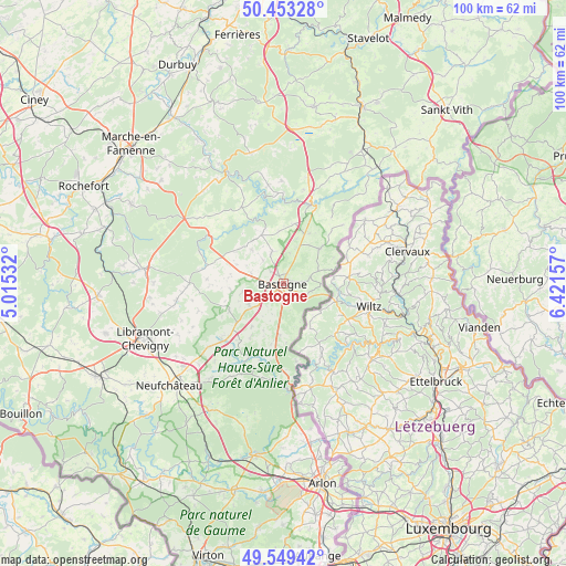
Bastogne GPS coordinates[2]
50° 0' 12.492" North, 5° 43' 6.384" East
| Map corner | latitude | longitude |
|---|---|---|
| Upper-left | 50.45328°, | 5.01532° |
| Center: | 50.00347°, | 5.71844° |
| Lower-right: | 49.54942°, | 6.42157° |
| Map W x H: | 100.5×100.5 km | = 62.4×62.4mi |
| max Lat: | 51.46791° ⇑95.3% North |
| Bastogne: | 50.00347° |
| min Lat: | ⇓4.7% South 49.53771° |
| min Long | Bastogne | max Long |
| 2.59368° | 5.71844° | 6.25749° |
| W 92.6%⇐ | ⇒7.4% E |
Elevation
Elevation of Bastogne is 502 m = 1647 ft, and this is 402.5 m = 1321 ft above average elevation for this country.
| Max E: |
582 m = 1909 ft | 0.40000000000001% |
| Bastogne | 502 m 1647 ft | |
| Avg. | 99.5 m = 326 ft | |
Min E: |
1 m = 3 ft | 99.6% |
See also: Belgium elevation on elevation.city.
Geographical zone
Bastogne is located in North temperate zone (between Tropic of Cancer and the Arctic Circle). Distance of this North polar circle is 1841.3 km =1144.1 mi to North.| Distance of | km | miles | from Bastogne |
|---|---|---|---|
| North Pole | 4447.2 | 2763.4 | to North |
| Arctic Circle | 1841.3 | 1144.1 | to North |
| Tropic Cancer | 2953.9 | 1835.5 | to South |
| Equator | 5559.9 | 3454.8 | to South |


Nearby cities:
15 places around Bastogne: (largest is in red/bold)
• Attert
28.6 km =17.8 mi,  170°
170°
• Bertogne
9.6 km =6 mi,  337°
337°
• Fauvillers
17.4 km =10.8 mi,  192°
192°
• Gouvy
25.7 km =16 mi,  37°
37°
• Houffalize
15.2 km =9.4 mi,  19°
19°
• La Roche-en-Ardenne
22.5 km =14 mi,  333°
333°
• Léglise
26.1 km =16.2 mi,  209°
209°
• Martelange
19.1 km =11.9 mi,  176°
176°
• Nassogne
30.2 km =18.8 mi,  297°
297°
• Neufchâteau
27.2 km =16.9 mi,  228°
228°
• Rendeux
29.9 km =18.6 mi, 329°
• Saint-Hubert
24.7 km =15.3 mi,  275°
275°
• Sainte-Ode
14.3 km =8.9 mi, 276°
• Tenneville
16.9 km =10.5 mi,  306°
306°
• Vaux-sur-Sûre
14.4 km =8.9 mi,  224°
224°
Sources, notices
• [Note1] Compared only with cities in Belgium existing in our database
• [Src1] Map data: © OpenStreetMap contributors (CC-BY-SA)
• [Src2] Other city data from geonames.org with taken over terms of usage.
• [Src3] Geographical zone / Annual Mean Temperature by Robert A. Rohde @ Wikipedia
