Bertogne geodata
Bertogne (Wallonia) is a populated place; located in Belgium in Europe/Brussels (GMT+2) time zone. With population of 2,852 people, there are 512 cities with bigger population in this country. Compared to other cities in Belgium, 93.7% of cities are located further ↑North; 91.2% of cities are located further ←West and 97.8% of cities have lower elevation than Bertogne. Note1
Administrative division(s):
- Level 1: Wallonia
- Level 2: Province du Luxembourg
- Level 3: Arrondissement de Bastogne
- Level 4: Bertogne


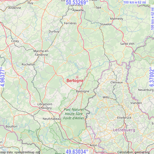
Bertogne GPS coordinates[2]
50° 5' 1.104" North, 5° 40' 0.804" East
| Map corner | latitude | longitude |
|---|---|---|
| Upper-left | 50.53269°, | 4.96377° |
| Center: | 50.08364°, | 5.66689° |
| Lower-right: | 49.63034°, | 6.37002° |
| Map W x H: | 100.3×100.3 km | = 62.3×62.3mi |
| max Lat: | 51.46791° ⇑93.7% North |
| Bertogne: | 50.08364° |
| min Lat: | ⇓6.3% South 49.53771° |
| min Long | Bertogne | max Long |
| 2.59368° | 5.66689° | 6.25749° |
| W 91.2%⇐ | ⇒8.8% E |
Elevation
Elevation of Bertogne is 429 m = 1407 ft, and this is 329.5 m = 1081 ft above average elevation for this country.
| Max E: |
582 m = 1909 ft | 2.2% |
| Bertogne | 429 m 1407 ft | |
| Avg. | 99.5 m = 326 ft | |
Min E: |
1 m = 3 ft | 97.8% |
See also: Belgium elevation on elevation.city.
Geographical zone
Bertogne is located in North temperate zone (between Tropic of Cancer and the Arctic Circle). Distance of this North polar circle is 1832.4 km =1138.6 mi to North.| Distance of | km | miles | from Bertogne |
|---|---|---|---|
| North Pole | 4438.3 | 2757.8 | to North |
| Arctic Circle | 1832.4 | 1138.6 | to North |
| Tropic Cancer | 2962.9 | 1841.1 | to South |
| Equator | 5568.8 | 3460.3 | to South |


Nearby cities:
15 places around Bertogne: (largest is in red/bold)
• Bastogne
9.6 km =6 mi,  157°
157°
• Fauvillers
25.9 km =16.1 mi,  180°
180°
• Gouvy
22.5 km =14 mi,  59°
59°
• Hotton
25.8 km =16 mi,  322°
322°
• Houffalize
10.3 km =6.4 mi, 58°
• La Roche-en-Ardenne
12.9 km =8 mi,  329°
329°
• Lierneux
24.1 km =15 mi,  21°
21°
• Manhay
23.2 km =14.4 mi,  1°
1°
• Nassogne
23.6 km =14.7 mi,  282°
282°
• Rendeux
20.4 km =12.7 mi, 325°
• Saint-Hubert
21.8 km =13.5 mi,  253°
253°
• Sainte-Ode
12.9 km =8 mi,  234°
234°
• Tenneville
9.9 km =6.2 mi, 277°
• Vaux-sur-Sûre
20.2 km =12.6 mi,  198°
198°
• Érezée
24.5 km =15.2 mi,  341°
341°
Sources, notices
• [Note1] Compared only with cities in Belgium existing in our database
• [Src1] Map data: © OpenStreetMap contributors (CC-BY-SA)
• [Src2] Other city data from geonames.org with taken over terms of usage.
• [Src3] Geographical zone / Annual Mean Temperature by Robert A. Rohde @ Wikipedia
