Herne geodata
Herne (Flanders) is a populated place; located in Belgium in Europe/Brussels (GMT+2) time zone. With population of 6,459 people, there are 411 cities with bigger population in this country. Compared to other cities in Belgium, 56.1% of cities are located further ↑North; 73.8% of cities are located further →East and 54.3% of cities have higher elevation than Herne. Note1
Administrative division(s):
- Level 1: Flanders
- Level 2: Provincie Vlaams-Brabant
- Level 3: Arrondissement Halle-Vilvoorde
- Level 4: Herne


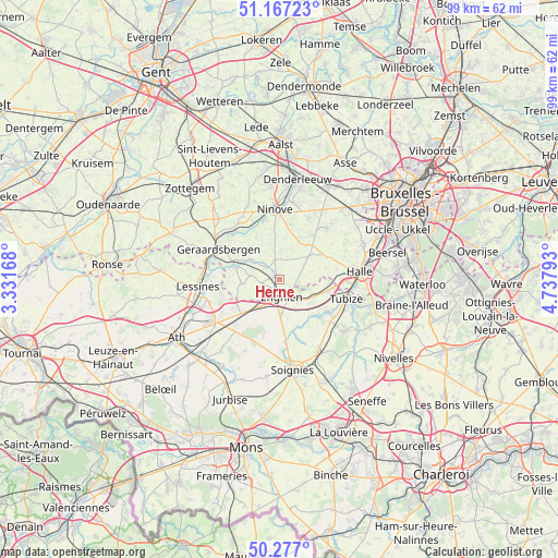
Herne GPS coordinates[2]
50° 43' 27.228" North, 4° 2' 5.316" East
| Map corner | latitude | longitude |
|---|---|---|
| Upper-left | 51.16723°, | 3.33168° |
| Center: | 50.72423°, | 4.03481° |
| Lower-right: | 50.277°, | 4.73793° |
| Map W x H: | 99×99 km | = 61.5×61.5mi |
| max Lat: | 51.46791° ⇑56.1% North |
| Herne: | 50.72423° |
| min Lat: | ⇓43.9% South 49.53771° |
| min Long | Herne | max Long |
| 2.59368° | 4.03481° | 6.25749° |
| W 26.2%⇐ | ⇒73.8% E |
Elevation
Elevation of Herne is 43 m = 141 ft, and this is 56.5 m = 185 ft below average elevation for this country.
| Max E: |
582 m = 1909 ft | 54.3% |
| Avg. | 99.5 m = 326 ft | |
| Herne | 43 m = 141 ft | |
Min E: |
1 m = 3 ft | 45.7% |
See also: Belgium elevation on elevation.city.
Geographical zone
Herne is located in North temperate zone (between Tropic of Cancer and the Arctic Circle). Distance of this North polar circle is 1761.2 km =1094.4 mi to North.| Distance of | km | miles | from Herne |
|---|---|---|---|
| North Pole | 4367.1 | 2713.6 | to North |
| Arctic Circle | 1761.2 | 1094.4 | to North |
| Tropic Cancer | 3034.1 | 1885.3 | to South |
| Equator | 5640 | 3504.5 | to South |


Nearby cities:
15 places around Herne: (largest is in red/bold)
• Braine-le-Comte
15 km =9.3 mi,  148°
148°
• Enghien
4.5 km =2.8 mi,  181°
181°
• Galmaarden
5.6 km =3.5 mi,  306°
306°
• Geraardsbergen
12 km =7.5 mi,  297°
297°
• Gooik
9.6 km =6 mi,  35°
35°
• Halle
14.1 km =8.8 mi,  85°
85°
• Ledeberg
13.8 km =8.6 mi,  16°
16°
• Lennik
13 km =8.1 mi, 43°
• Lessines
14.1 km =8.8 mi,  264°
264°
• Ninove
11.5 km =7.1 mi,  357°
357°
• Pepingen
9.6 km =6 mi,  66°
66°
• Rebecq-Rognon
9.5 km =5.9 mi, 147°
• Silly
11.5 km =7.1 mi,  223°
223°
• Sint-Martens-Lennik
13.6 km =8.5 mi, 44°
• Tubize
12.3 km =7.6 mi,  107°
107°
Sources, notices
• [Note1] Compared only with cities in Belgium existing in our database
• [Src1] Map data: © OpenStreetMap contributors (CC-BY-SA)
• [Src2] Other city data from geonames.org with taken over terms of usage.
• [Src3] Geographical zone / Annual Mean Temperature by Robert A. Rohde @ Wikipedia
